Southwest semidesert grasslands are highly affected by a century of livestock grazing, disruption of historical fire regimes, prolonged drought, and non-native plant invasions. The USFWS has sought to rehabilitate semidesert grasslands in Buenos Aires National Wildlife Refuge in southern Arizona. Prescribed burns have been used extensively for the past three decades to enhance habitat conditions and restore grassland fire regimes. New methods are needed to monitor vegetation responses to fire and habitat changes important to species such as the critically endangered masked bobwhite quail (Colinus virginianus ridgwayi), antelope jackrabbit (Lepus alleni), and other wildlife that prefer productive grassland habitat. Remotely sensed data can be used to monitor changes in plant biomass; however, accurate field estimates must be first obtained to calibrate models based on remote sensing.
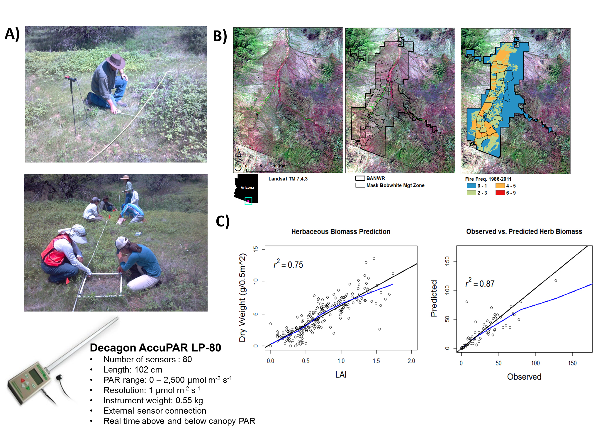
We tested the Decagon AccuPAR LP-80 PAR/LAI ceptometer (http://www.decagon.com/), which simultaneously measures photosynthetically active radiation (PAR; 400–700 nm) above and below grassland canopy cover, for calculating leaf area index (LAI) as a rapid biomass sampling tool. LAI is a measure of the amount of plant canopy on a site. We are using it for developing fine fuel measures in desert grassland (only in areas dominated by grasses and forbs, and very few woody plants). We used a total of n = 229 square 0.50 m x 0.50 m quadrats on n = 20, 20 m x 50 m plots to develop herbaceous biomass models. Grasses and forbs were clipped, dried, and weighed and compared with corresponding ceptometer LAI measurements. Regression-based models showed that LAI values alone were a strong predictor of plant biomass (p ≤ 0.0001, r2 = 0.75). Therefore, LAI alone explained 75% of the variation between measured and predicted plant biomass. Additional variables, such as amounts of grass and forb cover measured on quadrats, helped explain an additional 10% of the variation. Alternatively, models fit to a subset of the data (two-thirds) and tested on independent validation samples (one-third) showed r2 values > 0.90 for dry weight biomass. Field ceptometer measurements were a robust means for estimating plant biomass in this semidesert grassland.
Future work is aimed at combining non-destructive ceptometer and model-based biomass estimates with multitemporal satellite vegetation indices such as normalized difference and total vegetation indices to monitor landscape-scale fuel loads and habitat conditions over time. This work is part of a three-year study funded by the Joint Fire Science Program entitled “Determining Prescribed Fire and Fuel Treatment Compatibility with Semidesert Grassland Habitat Rehabilitation for the Critically Endangered Masked Bobwhite Quail (Colinus virginianus ridgwayi).”

A) Ceptometer LAI measurements combined with destructive sampling for fine fuel and biomass model parameterization, B) Buenos Aires NWR 48,000-ha study site within the masked bobwhite management zone and fire frequency strata developed from the USFWS Fire Atlas and Landsat time series dNBR data, C) Scatterplot comparing LAI with dry biomass weight (right) and a comparison of dry biomass model predictions with validation biomass data left out of model development (left).

