The OSMRE Alton Field Division (AFD) inspectors have been working with Kamiliah Lograsso, a physical scientist in the OSMRE Mid-Continent Regional (MCR) office Program Technology Support Branch (PTSB), to incorporate geospatial technologies into field inspections. High-resolution imagery is used to evaluate sites before a field inspection. Some examples include confirming that there is no disturbance outside of a permit boundary or locating areas of potential acid mine drainage, among many others. Furthermore, a Samsung Galaxy Tab® tablet with a GPS application and high-resolution satellite imagery, provided by OSMRE for use during field inspections, allows the inspector to capture features and take notes with greater accuracy in less time.

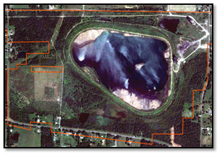
Figure 1. Evaluating high-resolution imagery before a field inspection allows the inspector to identify possible non-compliance issues. This example shows a permit boundary over a WorldView-2 satellite image. In this example, the graphic does not show any potential disturbance outside of the permit boundary (in red), so the inspector would not have to spend extensive time in the field evaluating potential non-compliant disturbance for this site. Disturbances outside of the permitted area are a violation of State and Federal regulations.

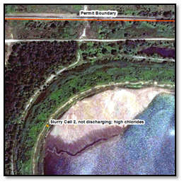
An example of a GPS point in orange, and labels (captured with a Samsung Galaxy Tab® tablet with a GPS application) acquired during a field inspection. The high-resolution WorldView-2 imagery indicates the location of the discharge point and coal washing waste pond in relation to each other at the mining site. For a more comprehensive look and analysis of the site, the graphic would be included in an inspection report.
AFD has stated that use of GPS and imagery has enhanced the overall effectiveness and efficiency of the inspection reports and field inspections. The MCR is continuing to explore options that save time and the costs of field inspections using geospatial technologies such as these.

