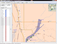
Pilot-biologists in the Branch of Migratory Bird Surveys (Division of Migratory Bird Management) collect georeferenced locations of aerial flight hazards during annual migratory bird surveys across the United States and Canada. Hazards include powerlines, meteorological towers, wind turbines, and other obstacles near transect lines flown by aircraft during low-level surveys. These locations are entered into a hazards geodatabase managed within the Migratory Bird Program that is used by pilots preparing flight plans. Pilot-recorded hazards are integrated with existing Federal Aviation Administration (FAA) hazard data and loaded on GPS units in survey aircraft to alert aerial crews of obstacles during future surveys. This effort is especially important for surveys conducted in remote regions of Canada, where information on obstacles is scarce.

Mapping locations of hazards for use in flight planning and GPS displays for aerial surveys.

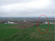
Barely visible meteorological tower hazard (circled) near waterfowl survey transect.

