In 2015, NASA, the National Geospatial-Intelligence Agency (NGA), and the USGS released a collection of higher resolution (i.e., more detailed) elevation datasets for most of the globe. The broad availability of more detailed elevation data through the Shuttle Radar Topography Mission (SRTM) will improve baseline information that is crucial to investigating the impacts of climate change.
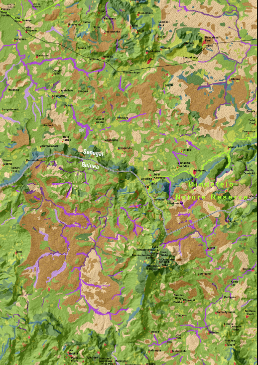
Using Landsat satellite imagery and 30-m SRTM digital elevation data, the USGS produced a detailed land use/land cover map for the biodiverse highlands along the Senegal-Guinea border. Land cover data from Landsat 8 combined with enhanced SRTM 30-m data produce a much improved map in three dimensions.
Even the remote transboundary area of the Senegal-Guinea highlands is beginning to feel the pressure of land use change, primarily as a result of people clearing more land for agriculture. At the same time, the region is experiencing a decline in rainfall as part of the overall pattern of climate change in West Africa. Among several species of primates in this area are chimpanzees that forage over large areas for food and shelter. The chimpanzee populations in Senegal are unique because of the special survival strategies they have adopted for coping in this harsh, semiarid environment. Habitats like gallery forests create their own microclimate and thus provide a critical refuge for many species of plants and animals during the long, hot dry season.
http://www2.jpl.nasa.gov/srtm/

Land cover data from Landsat 8 combined with enhanced SRTM 30-m data. North is oriented toward the top of the image.

