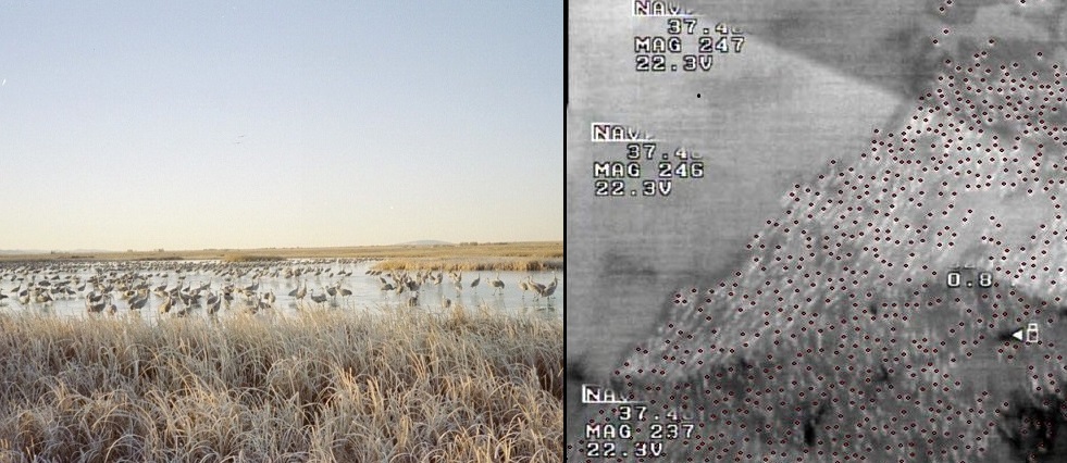
Federal, state, and Tribal natural resources management agencies conduct wildlife population counts either from the ground or via manned, low-altitude aircraft flights; both of these methods have limitations of accuracy, cost, safety, and timeliness. This project tested the capability of thermal infrared (TIR) sensors aboard the Raven RQ-11A small unmanned aircraft system (sUAS) to provide a source of accurate population estimates of sandhill cranes (Grus canadensis) and detection of breeding greater sage-grouse (Centrocercus urophasianus) in Colorado. The first FAA-approved sUAS flights within DOI were conducted in March 2011 (daytime) and 2012 (nighttime) to count sandhill cranes at Monte Vista National Wildlife Refuge near Monte Vista, Colorado. The 2011 flights confirmed the ability of the sUAS to provide reliable sandhill crane numbers; ground counts differed from those collected from sUAS imagery by only 4.6%. In 2012, 14,658 roosting cranes were counted during one night at three roosts on the refuge using an sUAS. In April 2013, the Raven sUAS was flown at two greater sage-grouse leks (breeding sites) near Kremmling, Colorado, to determine if the TIR sensor could detect greater sage-grouse (a smaller bird than sandhill cranes) and what reaction the sage-grouse might have to the aircraft. The sUAS was able to detect greater sage-grouse on their leks without disturbing their breeding displays. These studies demonstrate that sUAS technology, now available to natural resource managers, provides a non-intrusive, safe, and accurate way to track wildlife population numbers, health, and trends.
https://www.fort.usgs.gov/science-feature/127

Traditional, ground-based view used for population estimation of sandhill cranes on roost at Monte Vista National Wildlife Refuge, near Monte Vista, Colorado, and small unmanned aircraft thermal infrared image (dark dots indicate individual sandhill cranes). (USGS Image)

