The USGS-Alaska Volcano Observatory (AVO) is partnering with researchers at NOAA Environmental Satellite, Data and Information Service (NOAA-NESDIS) to incorporate their satellite-based retrieval products into volcano monitoring operations and response. Volcanic ash is the greatest hazard from eruptions in Alaska, and satellite monitoring has been utilized by the AVO for more than 25 years to evaluate unrest and to detect and characterize explosive eruptions. This new partnership with NOAA-NESDIS complements the USGS-AVO ground- and satellite-based monitoring by providing automated alerts of ash eruption and characterization of eruption cloud parameters such as height and erupted mass. In a pilot program, data products from AVO sensor networks will be provided to NOAA-NESDIS to aid in improving automated detection. The goal is an improved and consistent near-real-time evaluation of ash eruption hazard that is more timely and efficient. Retrospective analysis of past eruptions is underway and near-real-time alerts are being used by the AVO as part of their volcano monitoring system.

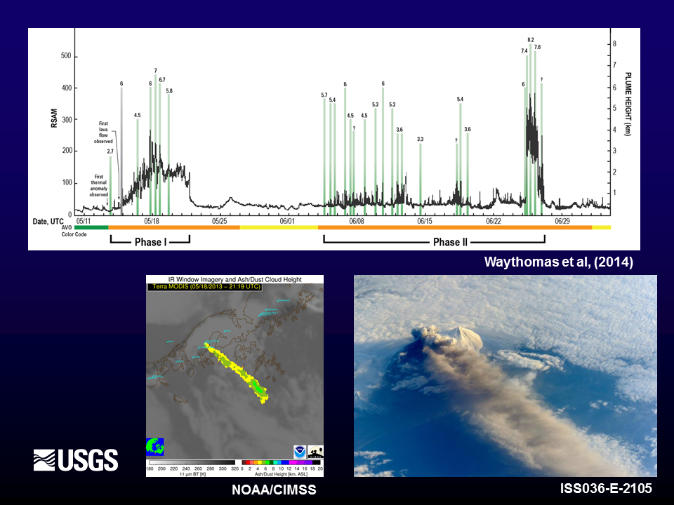
(Top) Plot of monitoring parameters from the May–June 2013 eruption of Pavlof volcano, Alaska. Seismic tremor amplitude (RSAM) is shown as the black line and varies throughout the eruption. Green vertical bars indicate eruption cloud height as determined by satellite, a critical parameter in the evaluation of eruption intensity and subsequent hazard. Note that RSAM and cloud height do not always correlate. The AVO-assigned aviation alert color-code is shown on the bottom of the plot (green = background state; yellow = elevated unrest; orange = escalating unrest/minor ash eruption). (Bottom left) NOAA-NESDIS retrieval of eruption cloud height on May 18, 2013. (Bottom right) International Space Station photograph of the eruption cloud on May 18, 2013.

