Soil carbon and permafrost are important drivers of future greenhouse gas emissions and vegetation communities. Accurately quantifying the magnitudes and spatial distribution of these soil properties is non-trivial because they are belowground characteristics that are not evident from the surface and they are heterogeneous in nature. As part of the USGS Alaska LandCarbon assessment, USGS scientists, in collaboration with other scientists, developed a series of soil carbon and permafrost maps for Alaska. This research also evaluated modeling results of the Dynamic Organic Soil version of the Terrestrial Ecosystem Model (DOS-TEM), which uses input data on soil texture, land cover, historical climate, historical fire, historical forest harvest, and model projections of future climate, fire disturbance, and forest management to estimate changes in ecosystem pools and fluxes.
Soil carbon and permafrost parameters from different map products were compared across 23 of Alaska’s major ecotypes. Average ecotype values from each soil characteristic were then compared to products from the DOS-TEM model. Agreement between DOS-TEM estimates and best estimates of current conditions built confidence in future predictions made with this model. DOS-TEM estimates fell in the range of mapped product estimates for total organic carbon (31–72 petagram versus 45 petagram), percent of area with near-surface permafrost (36–67% versus 44%), and percent of area with organic or peat soils (6–24% versus 18%). DOS-TEM was only slightly outside of the observed product range for active layer thickness or maximum thaw depth (76–84 cm versus 86 cm).
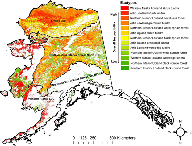
The data were then used to construct a rank-based index of susceptibility to changing climates based on permafrost vulnerability to degradation, organic layer susceptibility to fire, greenhouse gas emissions, and thawed carbon from permafrost. For each ecotype, the product means were averaged across map products to produce a single multi-product mean related to susceptibility. The susceptibility map highlights the expected sensitivity of tundra systems in western and arctic ecoregions to changing climates. Interior Alaska also has patches of moderate to high susceptibility.
Information obtained from multiple permafrost and soil carbon map products is useful for validation or as an input into models predicting future carbon emissions, hydrology, and vegetation communities. In addition, ecotypes with high mapping uncertainty or those with significant disparity with process-based model predictions identify areas where further studies or field data may be needed. The soil susceptibility map may also help identify areas in need of model refinement and should be informative for land use managers and agencies.
Wylie, B.K., Pastick, N.J., Johnson, K.D., Bliss, N.B., and Genet, H., 2016, Soil carbon and permafrost estimates and susceptibility to climate change in Alaska, chap. 3 in Zhu, Z., and McGuire, A.D., eds., Baseline and projected future carbon storage and greenhouse-gas fluxes in ecosystems of Alaska: U. S. Geological Survey Professional Paper 1826, 196 p., http://dx.doi.org/10.3133/pp1826.

Overall soil susceptibility index (based on greenhouse gas emission, burning, and permafrost thaw) for major Alaska ecotypes. White areas on the map have low susceptibility.

