How often does the Fairweather Fault break in large earthquakes along the outer coast of Glacier Bay National Park in southeastern Alaska? Researchers at the USGS Alaska Science Center are mapping active surface traces of the Fairweather Fault to identify sites that may answer this question and reveal the frequency and size of past large earthquakes. By assessing past earthquake activity of the Fairweather Fault, scientists hope to improve the USGS National Seismic Hazard Map for the southeastern Alaska region.
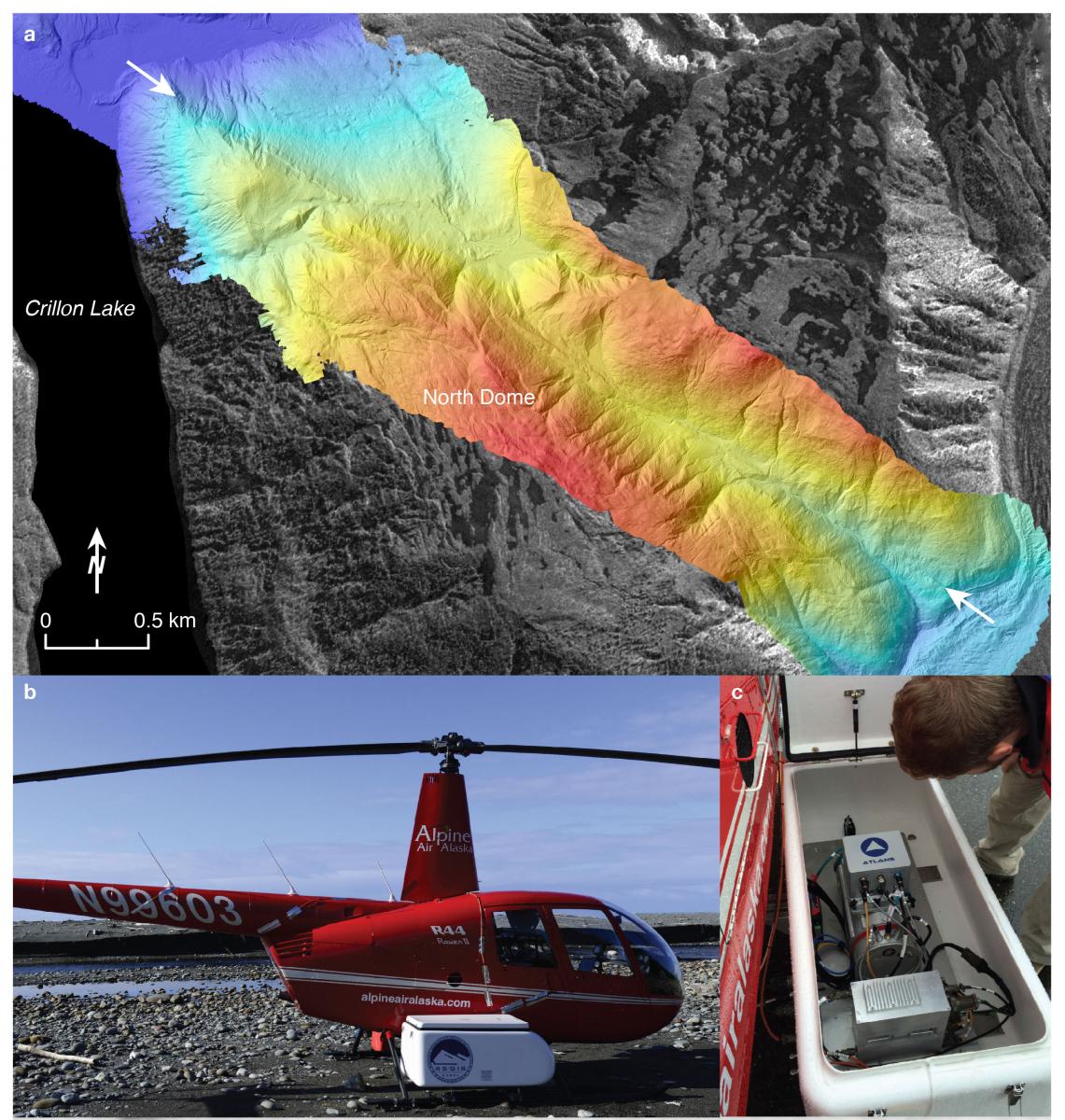
The 1958 Lituya Bay earthquake (M 7.7) ruptured more than 260 km of the Fairweather Fault in southeastern Alaska, where the Yakutat block collides obliquely with North America. The fault, which accommodates ~46 mm/yr of dextral slip (greater than 90% of the Pacific–North American Plate motion), ruptured from Yakutat Bay to Cross Sound and produced ~3–6.5 m of dextral offset as measured in post-earthquake surveys conducted along the southern ~30 km of the fault between Crillon Lake and Icy Point , including over 1 m of vertical offset at one site. To identify potential paleoseismic sites, USGS scientists searched for similar features using new airborne lidar topography, Interferometric Synthetic Aperture Radar (IFSAR) orthorectified radar imagery, and historical aerial photography to map the geomorphic expression of the southern Fairweather Fault in densely vegetated, steep terrain. A “HeliPod” helicopter-mounted lidar system surveyed three ice-free sections of the fault over areas 4–6.5 km long by 1–4 km wide. Bare-earth digital terrain models (DTMs) derived from last-return point clouds (~1 pt/m2) revealed structures consistent with earthquake offset, including 1–5-m-high mostly east-facing scarps, linear troughs, slope benches, shutter ridges, ponded alluvium, and dextrally offset landforms, including 12 stream channels offset 12–128 m, and 2 moraines offset 40–79 m.
Coupled with offshore bathymetry, data reveal a ~20° restraining bend and 3–4 km right step between offshore and onshore fault traces at Icy Point. South of the restraining bend, the linear offshore fault trace expresses strike-slip morphology. Within the bend, an array of right-stepping en-echelon folds and faults appear to accommodate transpression. North of the restraining bend, fluvial and marine terraces that only occur west of the onshore fault trace indicate west-side-up transpressional deformation. The change in deformation style across the restraining bend coincides with the southernmost impingement of the Yakutat block in southeastern Alaska. By using remote sensing data and new offshore bathymetric data together, researchers have identified promising field sites to assess the earthquake history along the southern Fairweather Fault.

(a) Color shaded relief map derived from lidar data acquired along the Fairweather Fault southeast of Crillon Lake. Warm colors reflect higher elevations; cool colors reflect lower elevations. Crillon Lake is ~100 m above sea level, whereas North Dome is over 800 m above sea level. The Fairweather Fault (arrows) forms a conspicuous crease through a narrow valley along the northwestern flank of North Dome. The black-and-white background image is 2.5-m resolution interferometric synthetic aperture radar (IFSAR) orthorectified intensity image (ORI) provided by the USGS. (b) Lidar data were collected using a “Helipod” system mounted onto a Robinson R-44 helicopter. (c) The laser scanner of the “Helipod” lidar system is in a box bolted to the side of the helicopter. The system also uses a GPS receiver to record geographic position, and an inertial measurement unit (IMU) to record angular velocity and acceleration data during the helicopter flight.

