A wide range of spatial forest disturbance datasets exist for the conterminous United States, yet inconsistencies among map products arise because of differing programmatic objectives and classification methodologies. Harmonized maps were produced from multiple data sources (i.e., Global Forest Change, LANDFIRE Vegetation Disturbance, National Land Cover Database, Vegetation Change Tracker, Web-enabled Landsat Data, and Monitoring Trends in Burn Severity) using a pixel-based data fusion process. The harmonization process, which involved fitting common class ontologies and testing spatial congruency, reconciled differences in forest fire, harvest, and other disturbances across four time intervals (1986–1992, 1992–2001, 2001–2006, and 2006–2011) by relying on convergence of evidence across all datasets available for each interval. Pixels mapped as disturbed for two or more datasets were labeled as disturbed in the harmonized maps. Results indicated that harmonization of readily available data increased data utility by incorporating causality information across input datasets, extending the monitoring period, and improving user’s accuracies. However, conservative rules for labeling a pixel as disturbed contributed to lower producer’s accuracies relative to the best available individual disturbance map. Omission errors were high for all forest disturbance maps due to underlying limitations in Landsat classification algorithms.

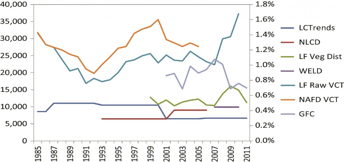
Annualized area of forest disturbance (sq km/year) and annualized disturbance as a percent of total forest (%) for CONUS across all readily accessible forest disturbance datasets created using Landsat imagery, including Global Forest Change (GFC), LANDFIRE Vegetation Disturbance (LF), National Land Cover Dataset (NLCD), data delivered to the LANDFIRE program by the North American Carbon Program using the Vegetation Change Tracker (VCT) process (referred to as LF Raw VCT), and Web-enabled Landsat Data (WELD). Estimates from the USGS Land Cover Trends Project and first version of North American Forest Dynamics Vegetation Change Tracker are included for comparison. Baseline forest used to compute percent disturbed was obtained from 1987 CONUS forest estimates included in the 2010 USDA Resources Planning Act (RPA).

