Detection of hurricane surge impacts requires regional mapping of surge flooding duration and estimation of abnormal change in wetland condition. To assess the impacts of Hurricane Sandy to coastal wetlands along the New Jersey Atlantic shore, USGS scientists studied the potential causal linkage of surge persistence and marsh condition. Surge persistence was estimated using a time series of TerraSAR-X and COSMO-SkyMed synthetic aperture radar (SAR)-based surge extents. Satellite Pour l’Observation de la Terre (SPOT) and Moderate Resolution Imaging Spectroradiometer (MODIS) were analyzed to estimate the loss of green biomass as a measure of marsh condition change before and after landfall.
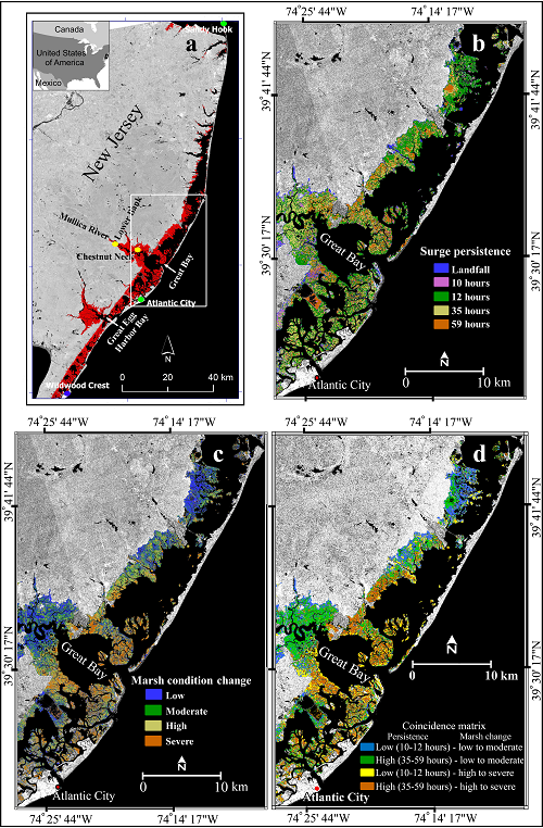
High correspondence in surge persistence and change in marsh surrounding and to the north of Great Bay suggest a causal relationship. Surge flooding persisted for 12 hours past landfall in marshes from Great Egg Harbor Bay to north of Great Bay. Surge persisted up to 59 hours surrounding Great Bay and decreased to 12 hours after landfall in marsh to the north. Marsh condition exhibited a similar intensity pattern: high change surrounding Great Bay decreased to low change in marsh condition moving to the north. The spatial correspondence of persistence and marsh condition change reflects the similarity in their spatial patterns. High persistence and high condition change exhibited high spatial correspondence in marsh surrounding Great Bay just to the right of where Hurricane Sandy made landfall. To the north of Great Bay, moderate to low surge persistence and marsh condition change showed high correspondence.
In contrast, non-correspondence of marsh condition change and persistence dominated the interior marshes of the Great Bay and Great Egg Harbor Bay estuaries. These estuaries exhibited little change in marsh condition while sustaining high flood persistence. Salinity measurements suggest that these areas were influenced by freshwater discharges after landfall possibly mitigating damage. Back-barrier lagoon marshes to the south of Great Bay exhibited a mixture of correspondences. High persistence was as often related with low as with high marsh condition change. Low persistence exhibited similar mixed correspondence.
These results provide a framework for monitoring wetland resilience and inundation patterns in order to protect floodplain ecosystems, mitigate flood hazards, sustain biodiversity, and contribute to effective land use planning.
http://dx.doi.org/10.1080/01431161.2016.1163748

(a) New Jersey coastal marsh study area (marsh in red, box outlines area shown in b, c, and d. (b) Surge persistence, (c) marsh condition change maps, and (d) the coincidence matrix showing their spatial association.

