LANDFIRE, the Landscape Fire and Resource Management Planning Tools Program, is a vegetation, fire, and fuel characteristic mapping program that provides information for strategic fire and resource management planning and analysis. It is managed by the U.S. Department of Agriculture Forest Service and the U.S. Department of the Interior, in partnership with The Nature Conservancy. LANDFIRE National, LANDFIRE’s first national extent spatial dataset describing existing and potential vegetation type and structure, surface and canopy fuels, and fire regimes, was completed in 2009. Since then, the existing vegetation, fuel, and fire regime layers of the dataset have been updated three times. The fourth and latest update, LF 2014, is in progress at the USGS Earth Resources Observation and Science Center.
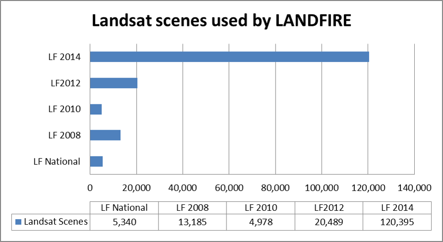
Landsat imagery plays a vital role in developing these LANDFIRE datasets. Multitemporal Landsat imagery is used to quantify annual landscape disturbances nationwide. The disturbance data are then combined with vegetation transition models to produce updated existing vegetation data layers, which are then used to update fuels and fire regimes data. Improvements in image compositing and tiling algorithms, plus faster, lower cost computing hardware, have enabled many more Landsat images to be utilized in LANDFIRE updates. Thus far, more than 100,000 Landsat scenes have been processed for the LF 2014 update, including both Landsat 7 Enhanced Thematic Mapper Plus and Landsat 8 Operational Land Imager imagery. Because Landsat scenes are reliable and highly calibrated, LANDFIRE products are consistent, comprehensive, and standardized, providing quality input to multiple fire, fuel, and natural resource applications.

Landsat imagery is vital to LANDFIRE data production. The graph above shows the number of Landsat scenes used to develop the LANDFIRE products listed.

