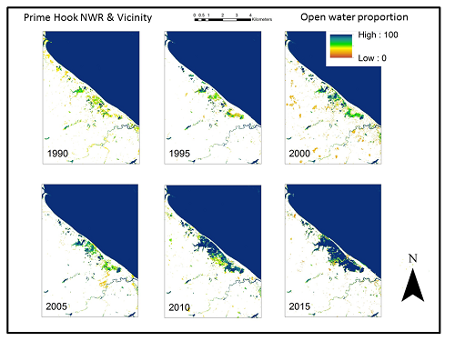
The Dynamic Surface Water Extent (DSWE) product under development at the USGS can be used to systematically characterize cycles and changes in surface inundation for a broad variety of applications. DSWE presents the results of tests for the presence of open water and mixtures of surface water and vegetation in Landsat Thematic Mapper (TM), Enhanced Thematic Mapper Plus (ETM+) and Operational Land Imager (OLI) image pixels collected over the United States. As one regional-scale example, DSWE data from 1984 through 2015 were used to calculate the yearly proportion of pixels free of clouds, cloud shadows, and snow that are classified as “open water” for the entire Chesapeake Bay Watershed (CBW). These proportions resulted in a time series of CBW areas that were consistently inundated on an annual basis. Such data can in turn be summarized over smaller areas such as watersheds or counties. A county-level assessment of changes between 1985 and 2015 in the CBW identified Sussex County as having a relatively large increase in perennially inundated area. A semi-decadal subset of these maps shows the consistent trend toward greater perennially open water in the area of the Prime Hook National Wildlife Refuge. Restoration efforts are currently underway to reverse this trend; the derivation of DSWE from Landsat images collected in the future will hopefully show decreases in open water as those areas are replaced by improved habitat (i.e., water/vegetation mixtures). Research is underway to increase DSWE thematic accuracy and temporal resolution by combinating Landsat scenes with other remotely sensed images and in situ monitoring data. For the end user, the DSWE product will provide a cost-effective, temporally consistent means of assessing inundation dynamics over intra- and inter-annual periods not only for habitat and water resource management, but for climate and land use change science and forecasting. This work is supported by the USGS Land Remote Sensing and Land Change Science Programs.
http://remotesensing.usgs.gov/ecv/SWE_overview.php

Maps depicting the proportion of times each year that a location was classified as “open water”. These images show an increase in perennially inundated land at the expense of vegetated wetland habitat in the Prime Hook National Wildlife Refuge, Delaware. Continued systematic collection and processing of remotely sensed data to standard, publicly available products will help managers efficiently assess whether restoration actions are producing intended results.

