In spring 2017, Denali National Park consulted with the NPS Alaska Regional Office (AKRO) to develop a project for the documentation of the aging Kantishna Roadhouse, a building located near the end of the Denali Park Road in Denali National Park. The goal of the project was to obtain measurements using a terrestrial laser scanner in order to facilitate the production of Historic American Buildings Survey (HABS) drawings that capture the existing condition of the structure. The Kantishna Roadhouse is considered eligible as a contributing structure to the Old Eureka/Kantishna Historic District.
High Definition Laser Scanning was conducted on the interior and exterior of the two-story log structure, which measures approximately 26 ft x 22 ft. Weather reports of inbound snowfall resulted in compressing available field time to one day. The speed of the terrestrial laser scanner (a Trimble TX8) allowed for one surveyor to acquire 16 scan positions, utilizing a combination of spherical and paper targets to facilitate registration.
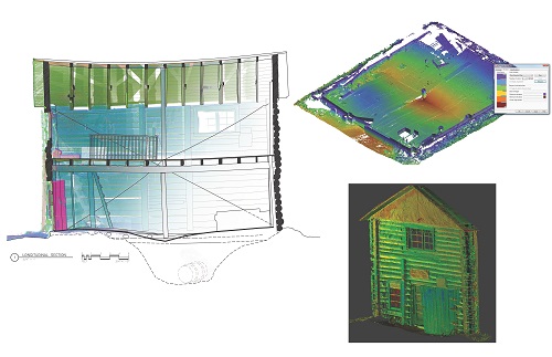
Structural deficiencies due to deteriorating wall logs and a settling foundation are visible to the naked eye when on site, but larger trends become visible in the processed point cloud dataset. The section shows the general slope of the building to the west (left), and the resulting failure in some structural members. Using different classification and visualization tools, the point cloud can be cleaned and cropped to isolate specific areas of interest, such as the deflection in the floor, or severity of deterioration for individual logs.
A set of architectural line drawings will be produced from the dataset and sent to the Library of Congress for inclusion in the Historic American Buildings Survey/Historic American Engineering Record/Historic American Landscapes Survey Collection of the Prints and Photographs Division. These collections document achievements in architecture, engineering, and landscape design in the United States and its territories through a comprehensive range of building types, engineering technologies, and landscapes. The collection can be found at https://www.loc.gov/collections/historic-american-buildings-landscapes-and-engineering-records/. Preserving and documenting the Kantishna Roadhouse as a noteworthy structure of the Eureka/Kantishna Historic District will offer historic insight for the Denali National Park, long after the building is gone.

Clockwise from left: Longitudinal section through point cloud with an overlay of the line drawing; point cloud shown isolating the ground floor and its deflection using a colorized elevation ramp; point cloud showing the west elevation of the Kantishna Roadhouse.

