Harmful algal blooms (HABs) are increasingly a global concern because they pose a threat to human and aquatic ecosystem health and cause economic damage. The most frequent and severe HABs in lakes and reservoirs are caused by cyanobacteria (CyanoHABs), the only freshwater algae that can produce toxins potent enough to adversely affect the health of humans, pets, livestock, and wildlife. Information about potential for exposure, such as bloom duration, frequency, and extent, is critical for effective management decisions, especially during periods of limited resources and funding. Rapid satellite-based approaches to detect and characterize CyanoHABs can improve the quality and timing of data delivered to resource managers and the public and allow monitoring resources to be focused in high priority locations.
The USGS is collaborating with the U.S. Environmental Protection Agency (EPA), National Aeronautics and Space Administration (NASA), and the National Oceanic and Atmospheric Administration (NOAA) on the Cyanobacteria Assessment Network (CyAN) project. The overarching goal of this collaborative effort is to detect and quantify CyanoHABs using satellite data records in order to support the environmental management and public use of lakes and reservoirs throughout the Nation. Information derived from ocean color instruments onboard multiple satellite platforms including Landsat, MERIS, Aqua, Sentinel-2, and Sentinel-3 is being used to create a standard approach for early identification of CyanoHABs in freshwater systems. Satellite remote sensing tools may enable policy makers and environmental managers to develop early-warning indicators of CyanoHABs at the local scale while maintaining continuous national coverage.
Algorithms to assess bloom frequency and severity have been developed and tested in two regions. Patterns of occurrence were reliably estimated, and the approach is being tested for broad applicability throughout the Nation. Limitations for successful implementation of the approach include satellite resolution and sensing capabilities. Currently available satellites with the highest resolution, such as Landsat, can capture 62% of lakes greater than 1 ha (2.47 acres) and 95% of the lakes with public drinking water intake locations. Unfortunately, these satellites make less frequent flyovers and are not equipped with sensors capable of distinguishing CyanoHABs from other types of HABs. Lower resolution satellites capture less than 1% of waterbodies and only 33% of drinking water intakes but make more frequent flyovers and can identify CyanoHABs.
This study is part of a larger effort of the USGS Environmental Health Mission Area to provide information that will help resource managers understand how to effectively minimize potential risks to the health of humans and other organisms exposed to cyanotoxins and other biogenic toxins through recreation, drinking water, and other exposure routes.
https://www.epa.gov/water-research/cyanobacteria-assessment-network-cyan
https://doi.org/10.1016/j.ecolind.2017.04.046 (Clark et al. 2017)
https://doi.org/10.1016/j.hal.2016.01.005 (Stumpf et al., 2016)
https://eos.org/wp-content/uploads/2015/12/15-Dec_Magazine.pdf?6874e7 (cover story)
https://www.epa.gov/water-research/cyanobacteria-assessment-network-cyan

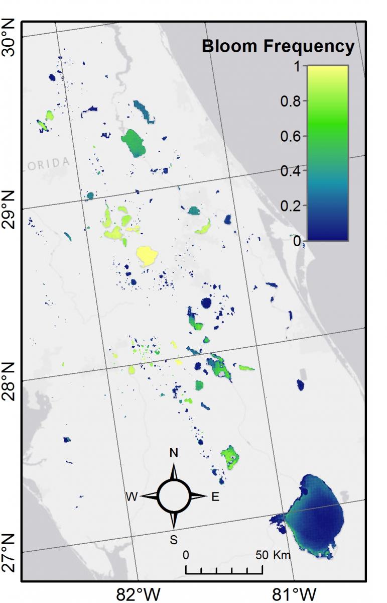
Map of the frequency of observed CyanoHAB occurrence above the World Health Organization (WHO) high threshold for risk of 100,000 cells per milliliter (cells mL−1) in central Florida lakes from 2008 through 2011. A value of 1 indicates that the pixel was observed to have CyanoHABs above the WHO threshold in all observations, and a value of 0 indicates that the pixel had no CyanoHABs above the threshold. Modified from figure 7, Clark and others, 2017.

