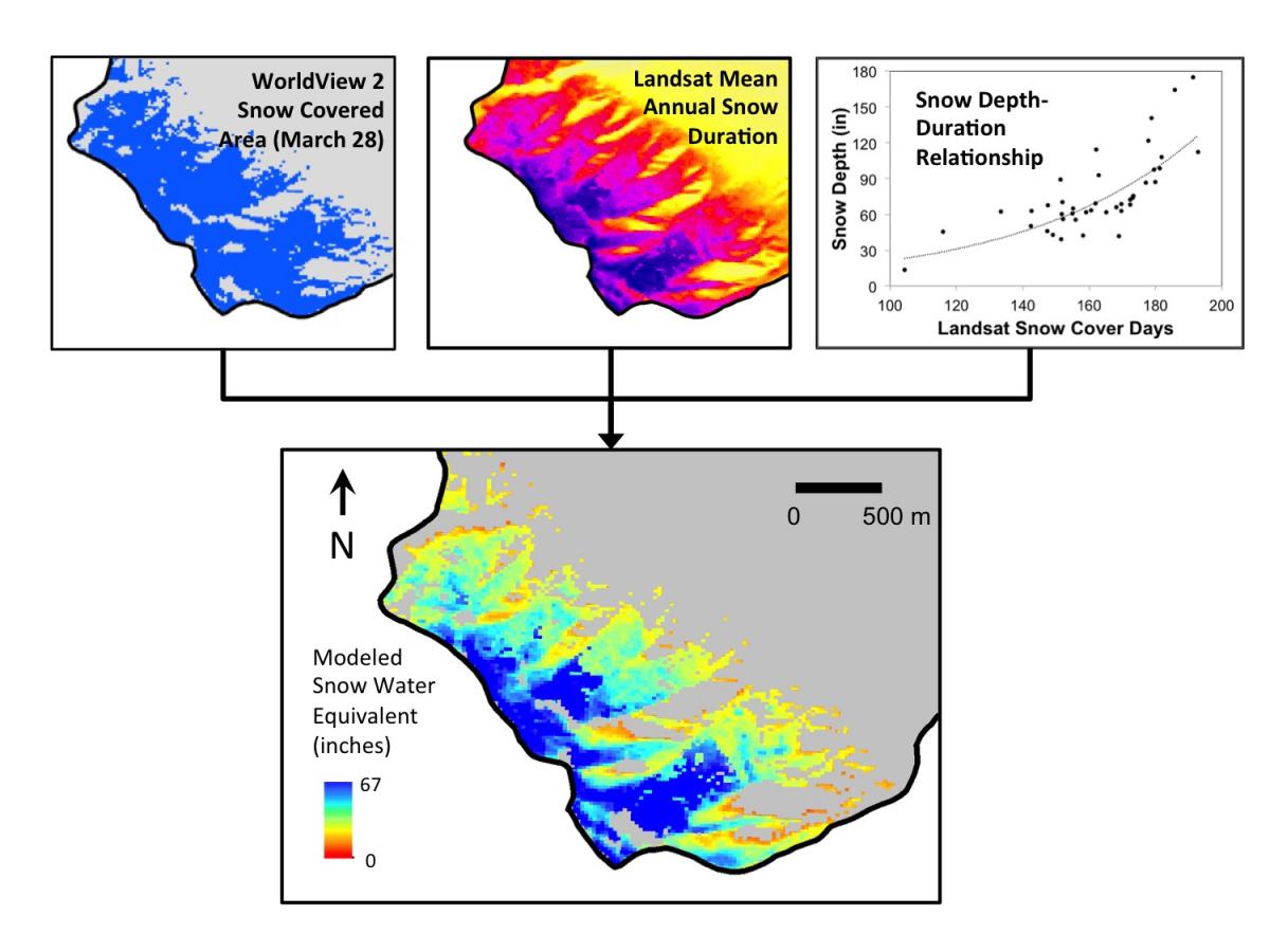
Record high precipitation over the winter of 2016–2017 across the central and northern Sierra Nevadas of California and Nevada resulted in flooding across the region. Silver Lake, a 3-km2 lake surrounded by industrial and residential development in Reno, Nevada, began to experience a substantial rise in water level in March, requiring a rapid response from the City of Reno emergency management services. In late March, the USGS collaborated with the City of Reno and Washoe County emergency management services to produce a rapid assessment of stored snow water equivalent and potential runoff for the Lemmon Creek drainage above Silver Lake. The Lemmon Creek drainage was ungauged and uninstrumented, and no high-resolution snow-free Digital Elevation Model (DEM) was available for use in a lidar differencing approach for estimation of snow cover height. Wind redistribution of snow cover and differences in incoming solar radiation resulted in variations in snow depth of up to 5 m over short distances, complicating efforts to conduct a traditional snow survey to estimate stored snow water equivalent. On March 28, teams conducted a specialized snow survey optimized for estimation of snow depth using Landsat-derived mean annual snow cover duration for 1984–2015 from the Landsat Snow Covered Area Science Data Product. Mean annual snow cover duration calculated using Landsat data showed a strong correlation with measured snow depth, allowing spatially distributed snow depth to be estimated using the combination of measured snow depth values and mean annual snow cover duration. Modeled snow depth was converted to snow water equivalent using density observations from the field and then constrained to pixels where snow cover was mapped from a WorldView-2 image acquired within 24 hours of the snow survey. The spatially distributed model of stored snow water equivalent was then used to provide an estimate of the anticipated rise in lake level for Silver Lake, allowing the city and county to take precautionary measures to prevent the lake from spilling over into structures adjacent to the lake.
https://nevada.usgs.gov/water/Flood2017/lemmonvalley.html

Remotely sensed snow covered area, mean annual snow cover duration, and snow depth and density measurements from the field (top row) were used to model April 1 snow water equivalent (second row) and potential contribution to lake level rise for Silver Lake in Reno, Nevada.

