
BOEM is working with the National Aeronautics and Space Administration (NASA) Atmospheric Chemistry and Dynamics Laboratory at Goddard Space Flight Center to assess the probability of using satellite data for air quality applications, specifically through the estimation and monitoring of offshore ground level concentrations of pollutants and through improvements and validations of BOEM's existing emissions inventories and photochemical modeling. BOEM is required to analyze Outer Continental Shelf (OCS) oil and gas activities' air quality impacts to the states as mandated by the Outer Continental Shelf Lands Act (OCSLA). These assessments are used by BOEM in National Environmental Protection Act (NEPA) Environmental Assessments (EAs) and Environmental Impact Statements (EISs). This study seeks to improve and add to the data for these assessments in support of BOEM's air quality regulations and NEPA analyses.
The Clean Air Act (CAA) requires the U.S. Environmental Protection Agency (USEPA) to set the National Ambient Air Quality Standards (NAAQS) for atmospheric pollutants; USEPA has set standards for six criteria pollutants: carbon monoxide (CO), lead (Pb), nitrogen dioxide (NO2), ozone (O3), particulate matter (PM2.5 and PM10), and sulfur dioxide (SO2). The OCSLA requires BOEM to ensure compliance with the NAAQS to the extent that OCS oil and gas exploration, development, and production activities can greatly impact the air quality of any state. Satellites have become increasingly capable of identifying and measuring the quantity of certain criteria NAAQS, their precursors, and assessing the impact of pollution on visibility. Although this capability has been identified, it has not previously been employed in the offshore environment.
In this study, NASA is improving the operational satellite NO2 data product, addressing several issues that will likely improve the use of the data over open water. With an improved NO2 product, the study will (1) estimate NO2 concentrations around offshore facilities, (2) determine the contribution of onshore emissions (such as specific refineries, power plants, and cities) to offshore air quality and vice versa by analyzing wind flow patterns and daily NO2 data, and (3) derive long-term trends over the last decade.
Additionally, a research cruise in the Gulf of Mexico is planned as part of this study to validate the remotely sensed data using NASA equipment to measure near sea level the same constituents observed by satellite. A website—Satellite Continental and Oceanic Atmospheric Pollution Experiment (SCOAPE)—is under development to share this project's goals and progress.
https://marinecadastre.gov/espis/#/search/study/100066
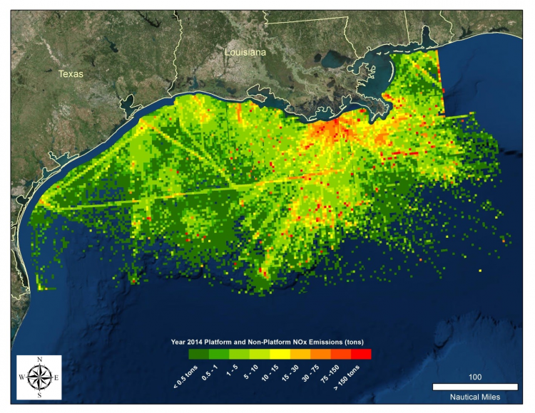
From BOEM’s earlier Year 2014 Emissions Inventory study, this figure—which was derived without satellite data—shows 2014 Gulf of Mexico offshore oil and gas platform and non-platform NOx emissions (tons). The research cruise called for in this study will use these data to help plot the course the ship should take to monitor emissions and validate the satellite data.