
The USGS National Land Imaging (NLI) Program is partnering with Federal agencies and the Administration’s Earth Observation Assessment (EOA) to document Earth Observation (EO) user requirements and measurement capabilities. NLI’s Requirements, Capabilities, and Analysis for Earth Observation (RCA-EO) branch has completed major accomplishments during this last year in establishing a full moderate-resolution satellite user requirements collection across the Federal Government with validation being done nationally and internationally. These requirements, in conjunction with the RCA-EO Capabilities, enhanced understanding of the remote sensing information needed to better support science and enable data-driven decisions.
RCA-EO Capabilities includes understanding and assessing the capability, performance, and quality of remote sensing systems and technologies, and provides an understanding of the sensors’ ability to support science needs. The RCA-EO Earth Observation Requirements Evaluation System (EORES) is an expanded database for documenting past, present, and future EO systems and their associated products and services. Information about each capability includes what is observed, where it is observed, how often, and how accurately.
The work of the Joint Agency Imagery Evaluation (JACIE) team, led by the USGS and partners from four other Federal agencies, is growing in importance as record numbers of Earth-observing satellites continue to launch. The JACIE team combines the efforts of the agencies to understand how well systems can meet the needs of science and land management, allowing industry and Government to work together to enhance capabilities and qualities of Earth-observing systems. To help track and compare these new satellites, the USGS RCA-EO Capabilities team is providing the first ever JACIE Land Remote Sensing Satellite Compendium. The RCA-EO will continue to expand capabilities analysis and use of the multi-agency user requirements to support Earth science and technology evaluations, Sustainable Land Imaging—requirements after Landsat 9, Landsat Application needs, DOI and USGS programmatic assessments, and analysis in support of the National Earth Observation Assessments.
The USGS RCA-EO project looks forward to continued collaboration across the DOI and its external partners to provide insight into the rapidly growing needs and capabilities for observing and studying our Earth to best serve the science users’ needs. Website: http://remotesensing.usgs.gov/rca-eo/.
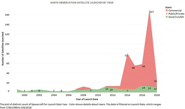
Earth Observation Satellite launches by year.