
Water resources are one of the Nation’s most important natural resources, especially for America’s farmland. However, changes in water management, land use, population, and climate are placing unprecedented demands on water supplies in the United States. Irrigated agriculture is one of the heaviest consumers of water resources in the western United States, and decision makers, water management agencies, and American farmers need to know that there is enough water to meet national needs, despite the increasing frequency of droughts and declining water levels in aquifers and reservoirs.
To understand the availability of water, it is important to quantify and assess current demand. Quantification of water demand in the western United States requires an understanding of long-term spatial and temporal trends in water use using consistent datasets and scientific methodology. In collaboration with the USGS Earth Resources and Observation Science Center, the Bureau of Reclamation is updating irrigation water use estimates presented in the Colorado River Basin Consumptive Uses and Losses reports for the lower basin for the period 1970–2015. Water use estimates at every 5-year mark from 1985–2015 are now complete and water use for 1975 and 1980 is currently in development.
Remote sensing with imagery from Landsat provides a cost-efficient and effective dataset for estimating water use with available datasets dating back to the late 1970s/early 1980s. Landsat provides a unique and powerful opportunity to evaluate the spatial and temporal trends in crop water use for large regions of the United States. Researchers used Landsat thermal data with the Operational Simplified Surface Energy Balance (SSEBop) modeling approach to quantify evapotranspiration (ET) at 5-year intervals between 1985 and 2015 for the entire Lower Colorado River Basin. A total of 5,735 Landsat images were processed from Landsat 5, 7, and 8. SSEBop ET was used to determine annual water use estimates for the basin.
Remote-sensing-based ET makes it possible to determine water use at monthly, seasonal, and annual time scales for each year in the Lower Colorado River Basin. SSEBop ET provides a consistent method of determining water use at multiple spatial and temporal scales. Water use trends can be determined for individual agricultural fields or basinwide areas and show the change in these areas over time. Understanding the historical water demand and usage over time can help guide water managers and farmers on the water needs for farmland in the basin.
The quantification and mapping of crop water use using remote sensing has several advantages: (1) remote sensing provides spatial detail as opposed to basin averages, (2) the data are consistent across multiple locations, so the estimates are comparable across state boundaries, and (3) consistency of data allows trend analysis over time. The EROS Center scientific staff can quickly and efficiently process thousands of Landsat images and convert them into ET water use maps.
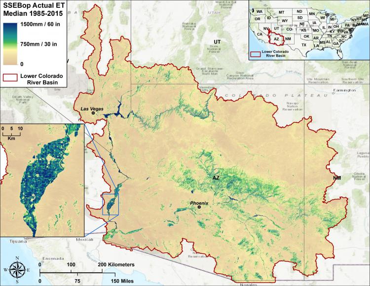
Median annual ET estimates for the Lower Colorado River Basin obtained from the SSEBop model at 5-year increments between 1985–2015.