
Meeting demand for agricultural water use and ecosystems has become a challenge for the Upper Klamath Basin, which stretches across southern Oregon and northern California. This basin is home to several threatened and endangered species and to more than 200,000 acres of irrigation land on the Bureau of Reclamation’s (BOR) Klamath Project. Since the 2013 adjudication of water rights claims in the basin, curtailment of irrigation diversions has occurred in the tributaries to Upper Klamath Lake; however, the hydrologic impact of the curtailment is not fully understood.
With funding from the BOR and the USGS Oregon Water Science Center, USGS researchers used Landsat thermal data coupled with weather data to quantify evapotranspiration (ET) for the base (2004 and 2006) and target years (2013–2016) to quantify crop water use with the Operational Simplified Surface Energy Balance (SSEBop) modeling approach. Landsat-scale consumptive water use maps for baseline and target years were then estimated and combined with gridded rainfall, gridded runoff, and stream gage data to generate volumetric savings (extra water available) from the irrigation curtailment. The ET analysis also quantified the source of the extra water available from surface water, groundwater, and conjunctive water use irrigation types.
This study demonstrated the usefulness of remote sensing information to monitor and quantify the hydrologic impact of the irrigation curtailment. With respect to the baseline years, results indicate that the increase to streamflow (extra water available) from irrigation curtailment over June–September was the highest in 2013 and gradually declined thereafter. For example, for the Sprague River at Chiloquin station, irrigation water savings (from all irrigation types) for 2013, 2014, 2015, and 2016 were 16,300, 6,000, 800, and 0 acre-feet, respectively. The general temporal patterns in extra water available estimates were found to compare well with other independent assessments. This approach is garnering attention not only by USGS Water Science Centers but also by several other Federal agencies. Understanding the hydrologic impact of a water management program (such as irrigation curtailment) aids management agencies in policy and decision making.
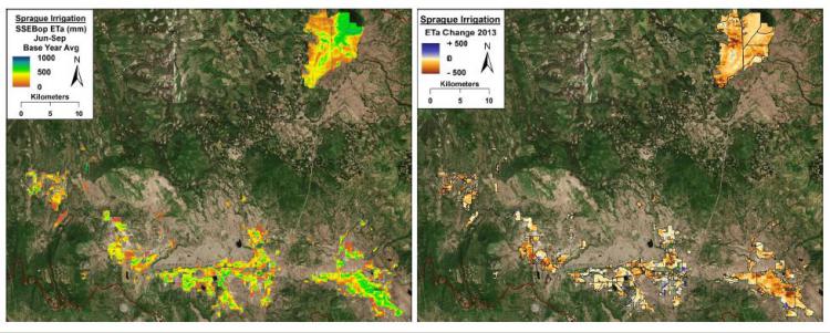
Sprague River, Oregon, irrigation map showing variability in mean actual evapotranspiration (June–Sept) over the base years (2004 and 2006 average) compared to the anomaly map from 2013. Larger brown areas indicate areas of water savings.