
Accurate assessment of ongoing land subsidence and ground failure requires periodic imaging of the ground surface and reconstruction of topographic changes over multiple timescales. The USGS monitors active land-surface deformation of playas occupying Red Pass and Bicycle Basins in the Mojave Desert to evaluate the influence of tectonic stress, fault barriers to groundwater flow, and declining groundwater levels due to pumping in nearby wells. Interferometric Synthetic Aperture Radar (InSAR) analyses and land surveys in Bicycle Basin show near-vertical change up to ~400 millimeters (mm) for the 1993–2015 duration at temporally and spatially variable rates. The spatial resolution (~25–30 meters [m]) of InSAR, however, is insufficient for the detailed study of gradually evolving fissures, desiccation cracks, and sink-like depressions.
USGS researchers tested the utility of photogrammetric unmanned aerial vehicle (UAV) surveys for repeat monitoring of centimeter to decimeter changes at a low cost relative to terrestrial and airborne lidar methods. Structure-from-Motion (SfM) techniques were used to gain depth information from sequences of overlapping photographs (>60%) collected via quadrotor UAV equipped with a 28-mm fixed-lens camera. An aerial survey of Bicycle Lake playa involved a two-tiered grid pattern flown at 10 meters per second (m/s) and altitudes of 122 and 183 m, yielding ground sample distances (GSD) between ~3 and 5 centimeters (cm). The USGS team constrained model geometries using the UAV track log and post-processed locations for 35 Propeller AeroPoints (portable ground control units) spaced ~500 m apart on the playa, providing an average density of ~5.4 targets per square kilometer (km2). The relatively rapid approach to imaging Red Pass Lake playa involved orbital and grid flight patterns at a steady altitude of 183 m but different views of ~30 and 10 degrees off-nadir. Ground control involved a relatively sparse arrangement of 10 targets spaced ~725 m apart with an average density of ~2.1 targets per km2. Consequently, the root mean square error (RMSE) of the team’s digital surface model for Red Pass Lake playa is ~20 cm compared with an estimated ~2.6 cm for Bicycle Lake playa.
Future photogrammetric collections at Bicycle Lake and Red Pass Lake playas will refine the approach and allow for change detection through differencing in the vertical or land-surface normal directions. The custom SfM-built topographic models are also compatible with high-resolution lidar topography (vertical accuracy of ~12 cm) collected December 2014. Taken together, these topographic datasets provide USGS scientists with the opportunity to evaluate physical processes over multiple timescales and predict the future response of desert basins to changing climatic conditions.
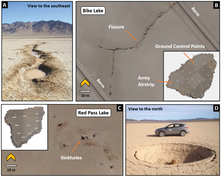
a) Field photo looking toward Tiefort Mountain to the southeast along a ~1-m-wide fissure that deforms the playa surface and impacts operations on the Bicycle Lake Army Airfield. b) Plan view of SfM-built orthophoto spanning fissure shown in (a). Inset shows overall extent of the 6.5-km2 orthophoto covering the playa. c) Plan view of colored 3D point cloud showing well-developed sinkholes affecting Red Pass Lake playa. Inset shows the total 4.7-km2 area of the SfM point cloud covering the playa. d) Field photo of a ~4-m diameter sinkhole (vehicle for scale) formed on Red Pass Lake playa.