
The USGS National Land Imaging Program (NLIP) has built a long-term capacity to collect and analyze land imaging user requirements to advance the Nation’s operational and science objectives and better serve the land imaging community. The USGS documents the land imaging requirements of U.S. Federal, state/local, academic, industry, and international users to promote needs-driven, prioritized investment decisions for land imaging systems, products, and services. Requirements are collected in a technology-agnostic format focused on spatial, spectral, and temporal needs, and can be readily compared to U.S. Government, commercial, and international capabilities to identify technology solutions, data gaps, or collaborative opportunities. The USGS has also collected information from Earth science subject matter experts about their current use of Earth observation (EO) technologies, which is useful for understanding the utility of specific EO systems across and within communities of use. These data have been used to evaluate the relative impact of USGS ground-based, aerial, and satellite data within the USGS Mission Areas and across the Federal and non-Federal user communities, and to promote USGS and Department of the Interior participation and inclusion in a wide range of activities. Some examples are the broad representation of USGS in the National Earth Observation Assessments, and greater USGS participation and user needs identification for the planned joint National Aeronautics and Space Administration-Indian Space Research Organisation (NASA-ISRO) Synthetic Aperture Radar (SAR) Mission (NISAR), and in other Federal imagery program development. NLIP has also provided the primary set of user needs and analysis tools for early formulation of the Landsat 10 mission. The importance of USGS user requirements activities continues to increase with the demand for smarter investments in land imaging technology to support vital societal needs in agriculture, water quality and availability, disaster mitigation, land resource management, and economic development.
https://remotesensing.usgs.gov/
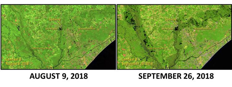
Example image from NLIP gallery showing flooding from Hurricane Florence. These images are centered near Conway, South Carolina, and are 35 miles wide with north oriented to the top. Hurricane Florence hit the Carolina coast on September 14, 2018, but it took much longer for the full impact to emerge. Remotely sensed images show the slow devastation that 13 trillion gallons of rain can bring as it moves back toward the sea, with before (left) and after (right) images depicting water as black. Conway saw some of its most severe flooding nearly 2 weeks after the storm made landfall. The Landsat 8 image from September 26 (right) shows the Waccamaw and Little Pee Dee Rivers swollen on either side of the city.