
The Landscape Fire and Resource Management Planning Tools (LANDFIRE) Program developed the original LANDFIRE National product suite using Landsat data (circa 2001) to identify disturbances on the landscape. Although these products were updated regularly (LF 2008, 2010, 2012, and 2014), the base layers themselves are now more than 15 years old. To make the base data current, LANDFIRE is remapping the United States to produce a new product suite. Remap, a comprehensive vegetation and fuels mapping effort that benefits from broadening program partnerships, combines consistent methodologies and processes to create a product that improves upon the updated versions of legacy LANDFIRE National.
Using newly available datasets such as Landsat 8 and airborne lidar, along with new data processing techniques, the LANDFIRE team at the USGS Earth Resources Observation and Science (EROS) Center is producing new vegetation, fuels, and fire regime base layers that represent circa 2016 ground conditions. To develop new Reference data, the team incorporated the newest data, eliminated geographic outliers, merged disturbance features, and integrated spectral testing of plots to discard plots that likely have experienced disturbance recently. Unlimited free access to the Landsat archive allows for the processing of more imagery to better identify specific land cover types or to create mapping masks to restrict where alpine or riparian/wetland classes can be modeled. Seamlines caused by date differences between adjacent images (path/rows) in the original base maps are being addressed by using more Landsat scenes along with improved preprocessing logic, resulting in more seasons of nearly cloud-free imagery and fewer phenological differences. Having better base imagery with fewer seamlines that represents a longer time series, combined with lidar data, provides stronger linkages with structure, resulting in an improved depiction of lifeform.
New products being developed through the Remap effort include Fuel Disturbance History (HDIST), Fuel Vegetation Height (FVH), Fuel Vegetation Cover (FVC), Fuel Vegetation Type (FVT), Dominant Cover Type, and Attributed Data: crosswalks to Society of American Foresters/Society for Range Management.
These layers more accurately represent disturbance scenarios within the fuels environment and leverage fuel transition assignments related to disturbed areas by re-establishing pre-disturbance vegetation.
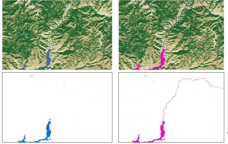
The Remap effort helps to better identify specific land cover types, such as water, and the National Hydrography Dataset provides narrow channel refinement. An area within Lincoln County, Idaho (left), from the National Land Cover Database 2011 shows water in blue and with LANDFIRE Remap (right) water is shown in pink.