
The USGS 3D Elevation Program (3DEP) is managing the acquisition of lidar data across the Nation for high-resolution mapping of the land surface, which is useful for multiple applications. While lidar data are available for many Department of the Interior (as well as other Federal) lands in the U.S., these data are underutilized for vegetation analyses, partly due to the lack of local personnel and software capable of processing and analyzing lidar data. Characterizing the 3D nature of vegetation using lidar data enables mapping vegetation height, structure, and volume over large areas. These mapped attributes have proven to be extremely useful for habitat studies, vegetation biomass and biomass change analyses, and wildfire behavior models.
In this project, USGS scientists developed methods to standardize vegetation metric geospatial product generation from 3DEP point clouds using scripting in Python and R; generated standardized metric products for two national park pilot areas (Shenandoah National Park and a portion of Grand Canyon National Park) via 3DEP lidar point clouds from five recent acquisitions; and developed a web front end to demonstrate product search, selection, and download of merged processed tiles at two spatial resolutions. The current processing framework includes use of licensed Python/LASTools scripts for pre-processing of lidar point clouds at USGS facilities, and the use of a custom distributable open source R package (USGSlvm) for vegetation metric generation from height-normalized point clouds. This framework provides “backend processing” to a web interface, which is the technology that processes the incoming request and sends the response to the user. The framework allows users to select desired products and processed tiles using graphical map selection tools and dialogs. Using server-side processing, the selected tiles are then merged together into seamless products, which are packaged and presented to the user for near-real-time processing.
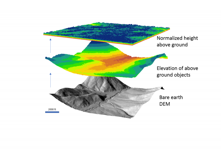
The typical 3DEP product is a high-resolution digital elevation model with all aboveground objects including vegetation returns removed (bottom). Normalizing vegetation heights to height above ground allows assessment of tree and shrub height, cover, and height variability (top).