
The lack of Pacific Islands topographic (land elevation) and bathymetric (water depth) information led Department of the Interior (DOI) researchers to use advanced remote sensing technologies to develop a topobathymetric digital elevation model (TBDEM) for Majuro Atoll, Republic of the Marshall Islands. With a maximum natural elevation of only 3 meters (m), Majuro Atoll is extremely vulnerable to changes in sea level, tsunamis, storm surge, and coastal flooding. Therefore, to support storm- and tide-induced flood modeling, the USGS Coastal National Elevation Database (CoNED) Applications Project collaborated with the DOI Pacific Islands Climate Adaptation Science Center (PI-CASC) (formerly the DOI Pacific Islands Climate Science Center) to develop this new data source.
The Majuro Atoll TBDEM was generated from Structure-from-Motion point clouds derived from unmanned aircraft system (UAS) photography, satellite-derived bathymetry from Landsat 8 and WorldView-3 imagery, and several other topobathymetric data sources to spatially integrate a 1-m TBDEM that extends offshore to a depth of at least 71 m in the lagoon. The temporal range of the input topography and bathymetry is 1944 to 2016. The new Majuro TBDEM consists of the best available multi-source topographic and bathymetric elevation data for the Majuro Atoll onshore and offshore areas.
This USGS research effort was in collaboration with the PI-CASC, the University of Guam, the University of Hawaii, National Oceanic and Atmospheric Administration/National Geodetic Survey, Marshall Islands Conservation Society, Republic of the Marshall Islands (RMI) Land and Survey Office, and RMI Environmental Protection Authority. The data are utilized by the scientific and resource management communities for global change research, hydrologic modeling, resource monitoring, and mapping and visualization applications.
https://topotools.cr.usgs.gov/coned/index.php, https://pubs.er.usgs.gov/publication/sir20185047, https://pubs.er.usgs.gov/publication/sir20185024
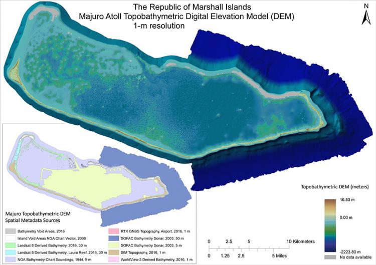
Majuro Atoll, Republic of the Marshall Islands topobathymetric digital elevation model (TBDEM).