
The Colorado River is the principal source of water for agriculture and riparian vegetation in Arizona, southern California, and southern Nevada. The BOR Lower Colorado Region accounts for water use in each state, verifies water conservation programs, and fulfills other water management information needs in the Lower Colorado Basin. To accomplish this, BOR monitors more than 3.5 million acres of agricultural land and riparian vegetation along the Lower Colorado River, from Hoover Dam south to the international border with Mexico.
Four times per year, BOR performs supervised classifications on every field along the mainstem Colorado River and the Imperial and Coachella Valleys, and along the Gila River. This is accomplished using a combination of multispectral satellite data, aerial images and ground-based field verifications. Roughly half of the collected verified fields are used to train the satellite imagery and determine the crop growing on each field for each time period. The other half of verified field data are used to assess the accuracy of each classification. Subsequently, data about the crop type and acreage along with evapotranspiration (ET) crop coefficients are used to estimate the ET from crops within each area.
BOR also maintains riparian vegetation and open water datasets to determine ET and evaporation from these sources. Each year, these datasets are updated using the best possible imagery (satellite or aerial) by performing change detection analyses. Results from these efforts are reported annually in the report “Lower Colorado River Annual Summary of Evapotranspiration and Evaporation.”
This information assists the BOR in meeting its U.S. Supreme Court mandate to provide detailed and accurate records of diversions, return flows, and consumptive use estimates of water diverted from the mainstem of the Lower Colorado River. This program is an example of implementing remote-sensing-based methodologies to meet the BOR’s water management needs.
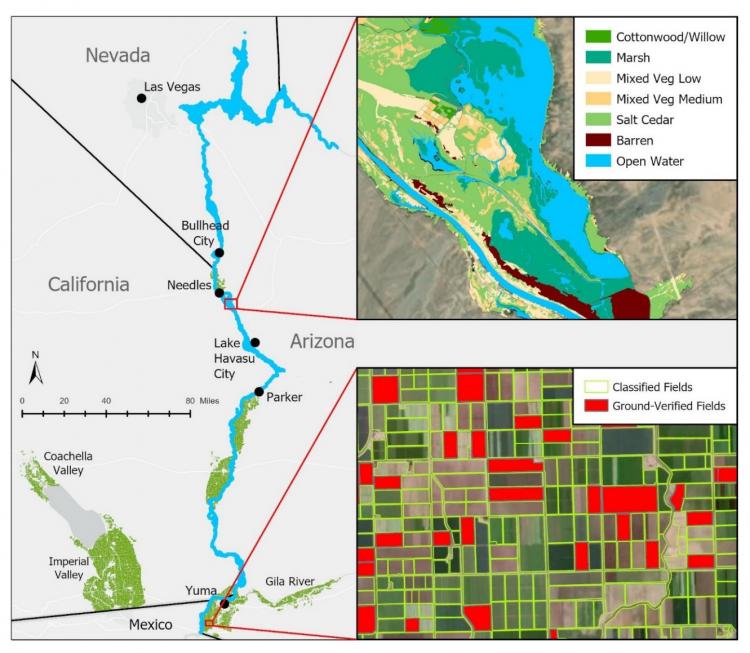
The BOR uses remote sensing and geographic information system (GIS) to map agricultural fields, riparian vegetation, and open water in order to estimate evapotranspiration and evaporation within the Lower Colorado Region (left). Examples of the riparian/open water databases near the Havasu National Wildlife Refuge, AZ (top right), and the agricultural database near Yuma, AZ (lower right).