
During the spring of 2014, about 105,000 acre-feet (130 million cubic meters) of water were released from the Morelos Dam in the United States into the delta of the lower Colorado River in Mexico, allowing water to reach not only the Colorado River’s delta but also the Gulf of California for the first time in 13 years. USGS scientists assessed the effects of ecological environmental flows from one nation to another using remote sensing. Remote sensing is used for water resource evaluation in vast and often inaccessible areas because these approaches can provide answers for binational, integrated water resources management and help to inform planning for the Colorado River, which includes seven states in the U.S. plus two states in Mexico. The effects of the 2014 historic binational experiment (the Minute 319 agreement of a water treaty between the U.S. and Mexico) were examined using satellite data to track evapotranspiration (ET, which is loss of water through evaporation from the soil and through plant transpiration), and vegetative greenness response captured using several vegetation indices (VIs), including the Normalized Difference Vegetation Index (NDVI), scaled NDVI, Enhanced Vegetation Index (EVI) and EVI2. Two satellite-based datasets were used: the 250-meter Moderate Resolution Imaging Spectroradiometer (MODIS) data and 30-meter Landsat 8 Operational Land Imager (OLI) satellite data.
The resulting time-series analysis from 2000-2018 showed an overall increase in VIs (higher greenness) and ET (more water loss) in 2014 (the year of the pulse) and in 2015 (the year after). This response reversed a decline in VI and ET since the last major flood in 2000, but the effect did not last after the first couple of years. The Minute 319 pulse flow produced a 17% increase in VI (“greenness”) as detected with Landsat throughout the riparian corridor in 2014. The greening up was observed across reaches within the riparian zone, as well as in the non-inundated outer parts of the riparian floodplain, where groundwater supported existing vegetation. However, just 2 years after the flow (by the end of 2016), there was a 22% decrease in VI throughout the riparian corridor. In 2017, an overall increase of 2% in greenness was calculated, before declining again in 2018 by 8%. From 2015-2018, the initial post-pulse vegetation green-up and increased ET captured by both Landsat and MODIS data steadily declined, falling to below pre-pulse levels in all reaches. The results indicate that these environmental flows from the U.S. to Mexico via the Minute 319 “pulse” had a positive, but short-lived impact on vegetation growth in the delta.
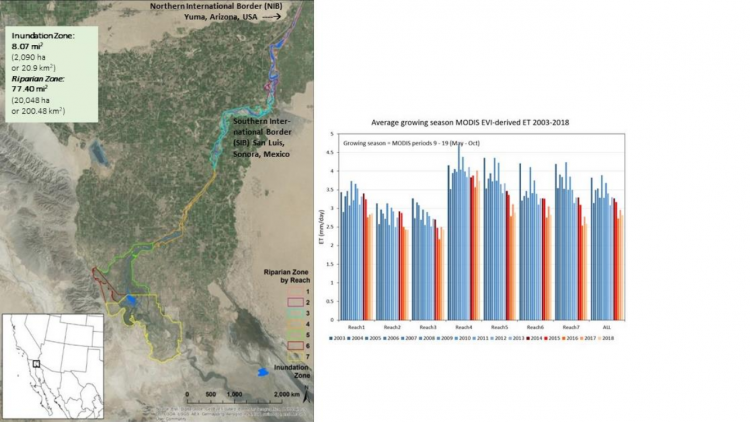
Map of the Colorado River Delta showing the seven Reaches of the Riparian Corridor and the Inundation Zone (the wetted zone). The inundated area tracked the flow from the Spring 2014 release of water from Morelos Dam on the U.S.-Mexico border, which flowed from the Northern International Border (NIB) past the Southern International Border (SIB) and throughout the delta to the estuary in the Sea of Cortez. The graph shows evapotranspiration (mm/day) from 2003-2018 for each of the seven Reaches, with the red color showing the years after the Minute 319 pulse flow.