
Cheatgrass is a highly flammable, prolific grass species that invades sagebrush ecosystems and creates extensive fuel beds that spread fire. The fires threaten homes, grazing lands, energy development, and wildlife habitat. To plan for upcoming fire seasons, land managers need spatially explicit maps at relevant spatial resolutions that provide early estimates of cheatgrass cover. Satellites provide consistent and reliable remotely sensed data that can be combined with machine-learning technology to map large geographic areas accurately, relatively inexpensively, and inform fire-planning activities.
Scientists at the USGS Earth Resources Observation and Science (EROS) Center are testing an innovative process that produces cloud-free, weekly growing-season vegetation index (Normalized Difference Vegetation Index; NDVI) data using remotely sensed, Harmonized Landsat 8 / Sentinel-2 (HLS) 30-meter spatial resolution data from the National Aeronautics and Space Administration (NASA). These data can be used annually to develop early estimates of cheatgrass cover. Beneficial to cheatgrass cover mapping, the HLS data provide frequent (2–3 days) sensor measurements that increase the chances of constructing weekly cloud-free image mosaics during the cheatgrass growing season. The data-capture frequency is advantageous because cheatgrass advances through its life cycle quickly in spring, and a less frequent data-capture schedule can miss data from critical cheatgrass growth stages.
The dataset’s 30-meter spatial resolution facilitates local-scale analyses, which is advantageous for many applications. For example, fuel breaks can be identified and analyzed for increases in cheatgrass cover, aerial herbicide spraying can be targeted, and the dataset’s scale better complements many land managers’ scale of work. Additionally, the collection of 30-meter pixels can be analyzed as a much larger unit, providing data at a landscape or pasture scale. The results of this data development are machine-learning models and maps that estimate cheatgrass cover pixel-by-pixel on an annual and spring “rapid” time step that can assist land managers with fire planning and serve as predictor variables for other ecological models.
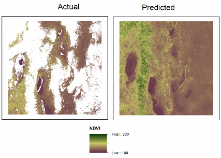
Actual and predicted (cloud-filled) vegetation index (NDVI) data from week 8 of 2016. White areas in the actual image identify where cloud contamination occurred. These areas were filled using a weighted mean of all non-cloudy, Harmonized Landsat 8 / Sentinel-2 data collected within 21 days of the cloudy date and created a provisional image. The provisional image was then modeled using machine-learning algorithms to produce the predicted image.