
Palmyra Atoll is a former World War II U.S. Naval air station that is now a wildlife refuge jointly managed by the U.S. Fish and Wildlife Service and The Nature Conservancy. To inform future terrestrial habitat restoration, including large-scale eradication of invasive coconut palm (Cocos nucifera) as well as recovery from localized contaminant remediations, woody stem crowns and vegetation communities at Palmyra Atoll were mapped using manual photo-interpretation of high-resolution aerial imagery collected using unmanned aircraft systems (UAS) in October 2016. Coconut palm, grand devil’s claw (Pisonia grandis), and numerous other species were delineated either as individual crowns, crown portions, or patches. The extent of land area at high tide was also delineated based on vegetation patterns, topographic indicators, and deposition lines of vegetation litter and flotsam. Finally, crown maps were used to delineate vegetation communities (based on the U.S. National Vegetation Classification System) and other management areas. Of the more than 44,000 mapped crowns, coconut was by far the most abundant species. By establishing a quantitative baseline for current habitat conditions, the data generated by this project play an important role in the integration of contaminant remediation recovery activities with habitat restoration planning, implementation, and monitoring at Palmyra Atoll.
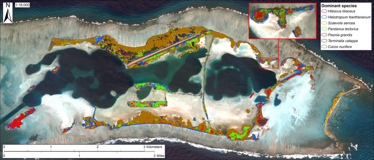
Coconut (Cocos nucifera) and other dominant mapped species crowns, crown portions, and patches at Palmyra Atoll (insert details Whippoorwill Island).