
Forest loss, forest succession, and wetland drying have been key issues on Alaska’s Kenai Peninsula in recent decades. Spruce bark beetle outbreaks, natural and human-caused wildfires, shrub expansion, lake drying, permafrost thaw, and industrial activities have all contributed to extensive land cover change across the peninsula. Detecting, mapping, and tracking the cumulative effects of these disturbances are important for State and Federal resource management agencies. Wall-to-wall land cover change analysis is presently difficult because of a legacy of different methodologies employed to document disturbances and classify land cover types through time.
USGS researchers are developing a Landsat-based time series of spatially explicit vegetation maps that are better suited to capture the extent and magnitude of various and prominent land cover changes that have occurred across the Kenai Peninsula over the last 40+ years. This study aims to develop a simplified and consistent series of spatially explicit vegetation and land cover types estimated from Landsat legacy imagery across the Kenai Peninsula between 1973 and 2017. While the main focus is on forest and non-forest, land cover types include needleleaf, broadleaf, and mixed species forests. Non-forest cover types include shrubs, upland and wetland graminoid, alpine, barren, and water. A time series composed of these classifications allows for the detection and quantification of forest losses, growth, and transitions as well as other major changes such as wetland loss due to drying and woody vegetation encroachment. This work provides a new record of landscape change and better quantifies how disturbance events and natural succession have shaped the distribution of vegetation types across the peninsula, an important resource for local, State, and Federal land managers tasked with monitoring and managing natural resources across the peninsula.
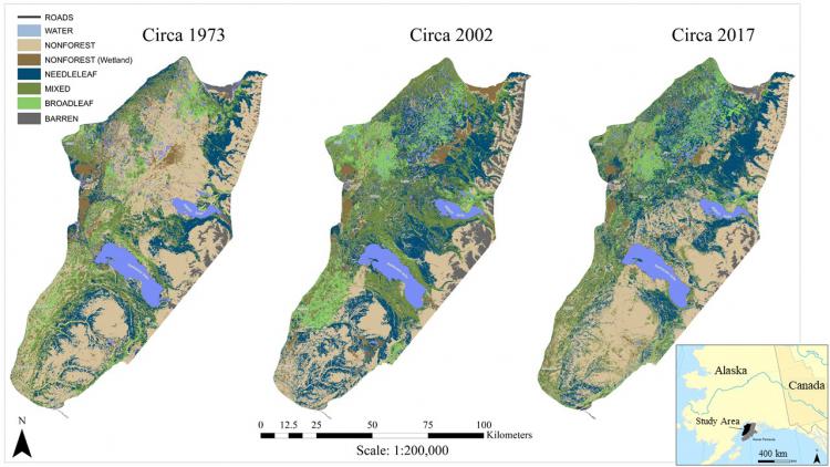
Current and historical vegetation maps derived from legacy Landsat images between 1973 and 2017. By comparing these land cover classifications in a geospatial environment, land cover change maps can be produced for the entire study area.