
Migratory species depend on a chain of habitats for survival, including breeding habitats, overwintering sites, and migratory stopover locations. Barrier islands in the northern Gulf of Mexico provide habitat for all three of these life-history phases and are important habitat for many shorebird species, such as Red Knots, Piping Plovers, and Western Sandpipers. Natural resource managers require tools for predicting how an island’s characteristics and a species’ use of available habitat may change over time and under varying management scenarios.
The first step in this process is developing a better understanding of how shorebirds utilize barrier island habitats under current conditions. However, the dynamic nature of barrier islands can make it challenging to establish a linkage between bird survey data that are sampled over time to a single snapshot of barrier island habitats and morphology. As part of the Coastal Resource Evaluation for Management Application (CREMA) project, scientists from the USGS St. Petersburg Coastal and Marine Science Center and the Wetlands Aquatic Research Center investigated how barrier island habitats were used by shorebirds and how those habitats changed on Pelican and Little Dauphin Islands, Alabama, over a single winter.
For this effort, monthly surveys were conducted using an unmanned aircraft system (UAS) from September 2018 through April 2019 to derive centimeter-level natural-color and multispectral ortho-mosaics as well as digital surface models using Structure-from-Motion (SfM) photography. In addition to UAS efforts, scientists conducted extensive vegetation and elevation surveys using a Real-Time Kinematic Global Positional System (RTK GPS) for training and validation. These data are being used to develop probabilistic maps of water levels on barrier islands and to produce bare earth digital elevation models from the SfM products. The lidar data and derivatives are coupled with field data, tide data and high-resolution orthophotography within a geomorphology-based mapping framework to produce a time series of maps of barrier island habitats (e.g., intertidal habitats, beach, and dune). The mapping framework uses a rule-based, geographic object-based image analysis approach and applies Monte Carlo analyses for the treatment of elevation uncertainty for elevation-dependent habitats. Finally, the team is also conducting monthly shorebird surveys to document bird behaviors and habitat use.
These products will be combined with other ecogeomorphic variables at multiple scales, such as distance from shoreline and vegetation cover, in a probabilistic model that relates shorebird habitat usage with landscape characteristics. This project aims to provide natural resource managers with tools needed to protect sensitive coastal ecosystems despite uncertainty in future conditions. In the coming years, the team is also considering moving this application to additional study sites.
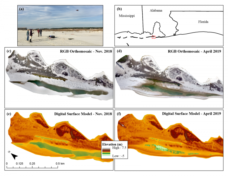
(a) USGS scientists fly an unmanned aircraft system (UAS) over (b) Pelican Island, Alabama, to collect data used to derive (c–d) natural-color ortho-mosaics and (e–f) digital surface models. UAS flights were repeated monthly from September 2018 through April 2019 in order to investigate how landscape features and shorebird wintering habitat availability change through time over a single winter. Note: elevations over water do not accurately represent water depth.