
The USGS is developing innovative technologies and approaches for measuring river discharge using remotely sensed data. Given the expense associated with remote sensing from conventional aerial platforms (e.g., helicopter, airplane), unmanned aircraft systems (UAS) offer hydrographers a lower cost alternative for data acquisition. As UAS-based techniques are non-contact, they have the potential of reducing the risks to personnel associated with making a discharge measurement during extreme events. If remote sensing of river discharge can be developed into an operational component of a gaging program, it could serve to augment and economize the current streamflow information network and facilitate the expansion of the network into ungaged basins.
The USGS Geomorphology and Sediment Transport Laboratory (GSTL) collaborated with the Atmospheric & Space Technology Research Associates Lidar Technologies (ASTRALiTe) to collect UAS-based topobathymetric lidar over a reach of the Blue River near Kremmling, Colorado. The field effort was undertaken to evaluate the capability of the ASTRALiTe edgeTM polarizing lidar sensor to collect river channel bathymetry. Bathymetric measurements are used to determine the cross-sectional area of a river, a parameter necessary for the computation of discharge. In addition, GSTL tested a UAS-based visible and thermal infrared camera system for tracking objects or features at the water surface and estimating their velocity. The visible camera requires floating objects or surface texture to be present in the imagery. The thermal infrared camera can be used to detect the motion of natural temperature variations produced by turbulent mixing that are expressed at the water surface. A time series of thermal imagery was acquired over the Blue River and processed with a large-scale particle image velocimetry (LSPIV) algorithm to calculate surface velocity. The surface velocity was corrected to a depth-averaged velocity and was combined with the cross-sectional area determined by the bathymetric lidar to produce a discharge estimate. Results comparing conventional discharge measurements made with an acoustic Doppler current profiler (ADCP) with the remotely sensed approach are encouraging.
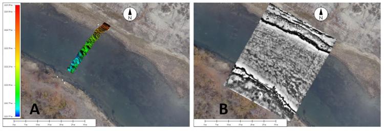
A) River bed elevation surveyed with a UAS-based bathymetric lidar, B) Infrared image of thermal structures.