
The National Map Corps (TNMCorps), a crowdsourced mapping project, relies on volunteers to assist the USGS National Geospatial Program by collecting and editing man-made structures data for The National Map. Through their participation, volunteers make important contributions to the USGS’s ability to provide the Nation with accurate mapping information.
Volunteers collect and update different structure feature types in all 50 states, as well as in Puerto Rico and the U.S. Virgin Islands. The structure feature types include schools, colleges and universities, fire and emergency management stations, law enforcement, prisons and correctional facilities, hospitals, ambulance services, cemeteries, post offices, courthouses, and city/town halls. Through a tiered-editing approach, volunteers improve the structures data by adding new features, removing obsolete points, and correcting existing data. The updates are then incorporated into The National Map and ultimately into U.S. Topo maps. As of July 2019, more than 1,800 users have made over 546,000 edits to over 433,000 unique points.
Getting started is easy. After walking through a simple registration process, volunteers begin editing using an internally developed web-based mapping platform that was released in August 2016. The primary base layer uses The National Map web services and consists primarily of 1-meter resolution digital orthophoto imagery provided by the U.S. Department of Agriculture National Aerial Imagery Program (NAIP), which is supplemented by 2-foot or better high-resolution orthoimagery over urban areas.
TNMCorps incorporates a variety of strategies to motivate and engage volunteers while simultaneously facilitating focused data collection resulting in high-quality data. These strategies include the tiered-editing process, mapping challenges, virtual recognition badges, social media engagement, bi-monthly newsletters, and regular news releases. Volunteers are from the general public and include youth from various organizations such as 4-H and scouting, retirees, students, and anyone with an interest in contributing to The National Map.
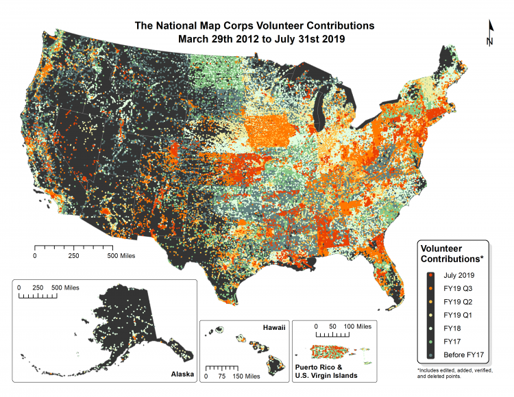
USGS TMNCorps volunteer contributions from March 29, 2012, to July 31, 2019. Each point on the map represents a single volunteer-edited structure feature. These volunteer contributions include edited, added, verified, and deleted points.