
Migrating waterbirds moving between upper and lower latitudinal breeding and wintering grounds, while crossing arid continental interiors, rely on a limited network of endorheic lakes and wetlands, which are waterbodies in closed basins with no outflow. Recent drying of global endorheic water stores raises concerns over deteriorating migratory pathways, yet few studies have considered these effects at the scale of continental flyways.
The resiliency of waterbird migration networks across western North America was investigated by reconstructing long-term patterns (1984–2018) of terminal lake and wetland surface water area in 26 endorheic watersheds. Findings were partitioned regionally by snowmelt- and monsoon-driven hydrology and combined with climate and human water-use data to determine their importance in predicting surface water trends. Nonlinear patterns of lake and wetland drying were apparent along latitudinal flyway gradients. Pervasive surface water declines were prevalent in northern snowmelt watersheds (lakes -27%, wetlands -47%), but surface water was largely stable in monsoonal watersheds to the south (lakes -13%, wetlands +8%). Monsoonal watersheds represented a smaller proportion of total lake and wetland area, but their distribution and frequency of change within highly arid regions of the continental flyway increased their value to migratory waterbirds.
Irrigated agriculture and increasing evaporative demands were the most important drivers of surface water declines. Underlying agricultural and wetland relationships, however, were more complex. Approximately 7% of agricultural lands linked to flood irrigation and water storage practices supported 61% of all wetland inundation in snowmelt watersheds. In monsoonal watersheds, small earthen dams, meant to capture surface runoff for livestock watering, were a major component of wetland resources (67%) that supported networks of isolated wetlands surrounding endorheic lakes. Ecological trends and human impacts identified in this study underscore the importance of assessing flyway-scale change as the model depictions likely reflect new and emerging bottlenecks to continental migration.
https://onlinelibrary.wiley.com/doi/full/10.1111/gcb.15010
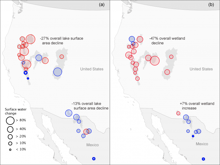
Magnitude of surface water change in the western United States and Mexico for 26 endorheic watersheds between 1984–2018. Change is partitioned by lakes (a) and wetlands (b). Statistically significant (p < .05) declines are shown in red and insignificant declines shown in blue. Increases to surface water area are shown in bold blue outline.