
Tumbesian dry tropical forests are found along the Pacific coast from southern Ecuador into northern Peru. They represent a region of substantial species endemism and seasonal forest conditions that differ from evergreen tropical forest. Remnant dry forest areas are essential for maintaining watershed conditions and a clean water supply, as well as providing high biodiversity values. Nevertheless, recent studies suggest that dry forests are increasingly degraded, as evidenced by declines in avian and plant species diversity.
Forest degradation, rather than loss, is increasingly important to understand and monitor in light of acknowledged ecosystem services derived from these forest remnants. The future magnitude and duration of El Niño – Southern Oscillation (ENSO) periods will potentially become more frequent, affecting forest environments in unforeseen ways. The relationship between intense drought periods and disturbance factors associated with dry-forest declines is not well understood. To estimate how climate extremes may impact dry forest, researchers are examining time series Moderate Resolution Imaging Spectroradiometer (MODIS) 16-day Normalized Difference Vegetation Index (NDVI, MOD13Q1) in conjunction with monthly MODIS daytime land surface temperatures (MOD11B3) and the climate hazards group infrared precipitation with stations data (CHIRPS v. 2.0). Permanent forest plots measured by the Universidad Técnica Particular de Loja (UTPL) provide repeated measures of forest conditions that can help distinguish fine-scale changes in forest composition related to drought and other disturbance effects.
Preliminary results reveal decreased dry-season NDVI corresponded to periods of decreased rainfall and continuously high monthly daytime temperatures. Between 2003 and 2005, 72 forest plots within southern Ecuador and Peru showed a pronounced decline in dry season NDVI, indicating possible system-wide climate effects on forest conditions. Other disturbance factors include fire observed from MODIS burned area data (MCD64A1) that exhibited one of the highest increases in burning for the Loja province and study area in 2005 following extreme drought. Factors such as fire, livestock grazing, fuel wood gathering, and other extractive forest uses may each play a role in degrading dry forest conditions that are likely exacerbated during drought periods. Future work seeks to estimate extreme climate effects and map the timing and magnitude of Tumbesian dry forest decline and recovery periods for Ecuador and Peru to examine conservation impacts over time.
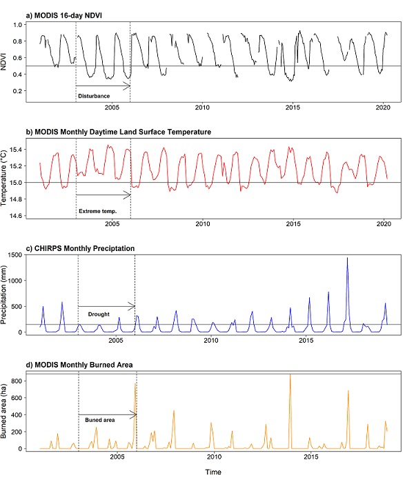
Tumbesian dry forest observations showing time series, a) NDVI and low dry season values between 2003 and 2005 for a single permanent plot, b) mean daytime temperature for the area overlapping forest plots in Ecuador and Peru, c) mean precipitation for the same area, and d) total burned area for the Loja province, where study plots are located. Dashed vertical lines (black) in each time series indicate the approximate timing of a pronounced ENSO event. Horizontal lines (black) for a) and b) are the first quantile values representing important climate extremes. The horizontal line (black) in c) shows the minimum observed precipitation value for the peak annual precipitation month. The horizontal line (black) in d) shows the maximum observed burned area in any one month, noting that 2005 showed two months with distinct increases in burned area versus 2013 that showed the single highest month following a period of higher daytime temperatures.