
The majority of America’s wetlands are located in Alaska (65%), but to date the FWS National Wetlands Inventory (NWI) Program has produced wetland data covering only 42% of the State. Areas without NWI data include over 31 million acres of the FWS National Wildlife Refuge System. Lack of wetland data limits understanding of habitats and impedes conservation of waterfowl, salmon, and big game, which is essential for supporting a stable economy and subsistence populations in Alaska. NWI data are also critical for strategic, cost-effective infrastructure development, especially during project planning, mitigation, and permitting stages. For these reasons, complete wetlands data coverage for the State is a critical priority for NWI, as well as for other Federal and State agencies and Tribes.
Remotely sensed imagery with a relatively fine spatial resolution is required for mapping wetlands, but such imagery has been difficult to obtain for Alaska due in part to low sun angles at high latitudes. Recent advances in satellite remote sensing provide new data to enhance the efficiency of wetland mapping. Specifically, the 10-meter synthetic aperture radar (SAR) and multispectral data provided by Sentinel-1/2 on a sub-weekly basis are major improvements over historical data. NWI, in partnership with the University of Maryland, recently completed an assessment of Landsat, Sentinel-1/2, and digital elevation data for supporting more time and cost-efficient NWI data production in Alaska. The project focused on the Selawik and Arctic National Wildlife Refuges and developed innovative algorithms integrated within a streamlined automated workflow supported by a high-performance computing system.
Maps of vegetation structure, subpixel water fraction (SWF), and wetlands were produced for 2016–2020. By providing subpixel estimates of fractional water cover within each 10-meter pixel, wetland features smaller than 5 meters could be detected. The water regime, vegetation, and wetland products were found to be well correlated with field data. The automated workflow made it possible to download and process more than 2,000 Landsat and Sentinel images for the selected study regions, which required over 1,200 central processing unit (CPU) hours and more than 10 terabytes (TB) of disk storage in a single run. These data provide unprecedented spatiotemporal information on wetland hydrology and vegetation dynamics in Alaska and have been well received by stakeholders. NWI is currently testing the utility of these products within an operational workflow.
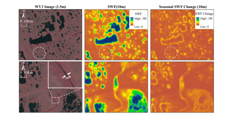
WorldView-3 imagery (WV3, left), subpixel water fraction (SWF, middle), and seasonal SWF change (right) maps derived using 10-m radar and optical observations from Sentinel-1/2 provide unprecedented spatial, temporal, and thematic information on wetland inundation dynamics over Alaska.