
Although the International Union on Conservation of Nature (IUCN) lists the Egyptian tortoise (Testudo Kleinmanni) as critically endangered, it is the least studied tortoise species in the Mediterranean basin. Limited literature documents the historical range of species in northern Africa's shoreline environments encompassing Libya, Egypt, and Israel that are characterized by scanty shrub vegetation under semiarid conditions. In addition to the illegal pet trade, the tortoise population is threatened by substantial habitat loss over the past few decades due to a tremendous rise in urban and agricultural development throughout the region, coupled with climate change.
This project's primary goal is to evaluate the spatiotemporal changes (1994–2019) in habitat loss within the shoreline environments of northern Africa using remote sensing techniques. Based on the rich archive of Landsat satellite data collected and distributed since 1972, the U.S. Geological Survey (USGS) recently initiated an effort to produce application-ready science products such as surface reflectance (SR) that are ideally suited for land cover change studies. SR data are atmospherically and geometrically corrected imagery based on Landsat sensors, consisting of a multispectral stack of four visible and near-infrared (VNIR) bands, two shortwave infrared (SWIR) bands, and one thermal infrared (TIR) band. For this project, cloud-free Landsat imagery (USGS Landsat 5 – TM, Surface Reflectance Tier 1, 30-m data) for May–June was identified for each of the two time periods (1994 and 2019) and clipped to produce a 50-km buffer image subset along the Libya-Egypt shoreline. Additional preprocessing of the multispectral data involved calculating spectral indices (NDVI, SAVI, MSAVI, NDWI, and EVI) based on specific combinations of the image bands that capture information on vegetation types, amounts and condition. The spectral data and derived indices were input to a supervised image classification routine using the Random Forest ensemble decision tree-based machine learning algorithms. A random sampling of pixels was visually identified and labeled on true- and false-color composites images to represent different cover types: low-intensity vegetation, high-intensity vegetation, urban, bare, and shrub.
Results of the preliminary analysis indicate a significant decrease (about 22%) in the areas classified as shrublands (potential tortoise habitat) with a concomitant increase (about 12%) in the bare class between 1994 and 2019. Additionally, urban and high vegetation (agricultural lands) classes showed a significant increase (115% and 28%, respectively), indicating a potentially detrimental effect on the tortoise populations. The remote sensing approach provided landscape level analysis and inventory of land covers for the Egyptian tortoise throughout its range, overcoming the sparsity of available field-based data and enabling effective decision making for land managers and stakeholders.
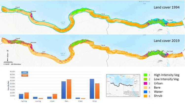
Land cover characterization between 1994 and 2019 for the project study area.