
Physical scientists at Kenai Fjords National Park in Alaska have been using remote sensing methods to monitor an unnamed glacial ice-dammed lake (IDL) and the subsequent glacial lake outburst floods (GLOFs) that regularly occur at Bear Glacier to understand the timing, frequency, and drivers that lead to GLOFs. These floods are occurring in a popular proglacial lake and may pose a risk to recreational users.
In 2017, a satellite-linked camera was installed and began emailing photos daily to be posted on the park’s website. Since then, two GLOFs were documented (August 2018 and August 2019). With assistance from the NPS Alaska Regional Office, aerial Structure from Motion data were acquired after the IDL drained to capture high-resolution digital elevation models (DEMs) and orthophotos of the lake basin. Researchers are using monoplotting and GIS software tools to analyze these DEMs and time-lapse photos to calculate rates of filling and discharge at the IDL and to estimate downstream flood magnitude.
Monoplotting is a photogrammetry technique that georeferences single terrestrial oblique photos by establishing ground control points of common features between photos and DEMs. The software uses these ground control points to apply real-world XYZ coordinates to the photo. This allows elevation changes to be extracted (e.g., rising and falling lake surface levels) from an oblique photograph.
Analysis is ongoing as the team continues to measure weekly lake elevations in the WSL Monoplotting Tool. Lake elevation values in GIS are created to generate polygon contours of the lake and derive IDL volumes with sub-meter accuracy in near-real time. By comparing current lake levels to previous GLOF events, park managers may be able to better assess the timing of future GLOFs and notify the public of a potential GLOF.
Quantifying sub-glacial lake volumes is complicated. At least 1.2 miles of the glacier was buoyed by the lake in 2018. Because the ice is thinning concurrently with lake filling (which results in ice flotation), it is difficult to determine the amount of water beneath and within the glacier. Results from the analysis of the visible portion of the IDL (the surface water) estimate the 2018 GLOF drainage event occurred at a lake surface elevation of 270.04 meters and a surface water volume of 75,700,000 cubic meters, or 30,280 Olympic-sized swimming pools. The true flood magnitude exceeds that estimate since the volume of water beneath the glacier could not be precisely determined.
https://www.nps.gov/media/webcam/view.htm?id=81B46C47-1DD8-B71B-0B906643D4461AF0
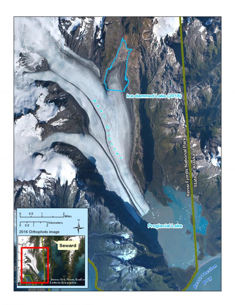
Map of Bear Glacier. When a GLOF occurs, the ice-dammed lake drains and travels down-glacier. This floods the proglacial lake, a popular site for paddlesport recreationalists. The blue polygon on the map indicates the extent of water dammed within, under, and next to the glacier prior to the 2018 GLOF.