
Invasive annual grass is problematic in much of the Great Basin and surrounding areas. Cheatgrass (Bromus tectorum) is by far the most pervasive of these grasses. It outcompetes native plants by completing its entire growth cycle--growing early in the spring, rapidly producing seed, and senescing--, before many native plants advance beyond initial growth phases. Cheatgrass thus depletes the nutrients and limited soil moisture available for native plants, which provide important vegetation structure and composition necessary to support a diverse range of wildlife species. Invasive grass cover also results in a dramatic change in fire fuel structure and patchiness that makes shrublands, especially sagebrush lands, more prone to wildfire. Fires in these dryland shrub communities are stand replacing with sagebrush recovery taking 18 years or more. Fires in these dryland systems are becoming larger and are occurring more frequently than sagebrush can recover – potentially threatening developed and key conservation areas. Near-real time invasive annual grass cover (0–100%) maps are made using machine learning to establish predictive relationships between spatiotemporal data inputs and field-measured invasive annual cover. The remote sensing components are heavily focused on the vegetation phenology of 30-meter cloud-free weekly vegetation index data derived from two satellites, Landsat and Sentinel-2. Predictive models of invasive cover combine the satellite data with soils information, elevation products, and land cover. Invasive annual grass maps inform land managers of current conditions so they can better conserve wildlife and livestock habitat, be aware of current fire fuel structure dynamics, and implement invasive species controls more strategically.
https://doi.org/10.5066/P9XT1BV2
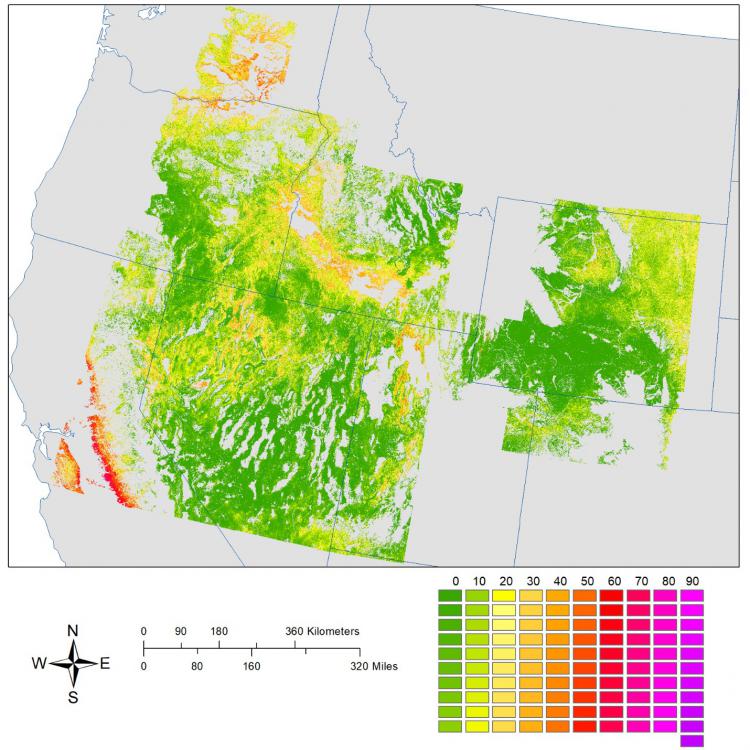
May 2020 invasive annual grass cover (0–100%) mapped at a 30-meter resolution. Non-rangeland is gray.