
Landsat satellites have been operating since 1972, providing a continuous global record of the Earth’s land surface. The imagery is currently available at no cost through the USGS. A previous USGS study estimated that Landsat imagery provided users an annual benefit of $2.19 billion in 2011, with U.S. users accounting for $1.79 billion of those benefits. That study, published in 2013, surveyed users in 2012 about Landsat imagery they retrieved in 2011. But since then, many changes have altered the demand for and supply of remotely sensed imagery and have made the analysis complex. This report updates these estimates, surveying users in 2018 about Landsat images they retrieved in 2017. The report discusses changes in the value per scene in 2017 when compared to 2011 and analyzes the potential consequences of charging fees. Landsat imagery has been available at no cost to the public since 2008, resulting in the distribution of millions of scenes each subsequent year. In addition, tens of thousands of Landsat users have registered with the USGS to access the data. Considering the number of Landsat data users worldwide and the broad range of Landsat data applications, it is difficult to quantify the cascading benefits to society provided by Landsat imagery. The value of Landsat imagery to these users was demonstrated by the substantial aggregated annual economic benefit from the imagery. Landsat imagery provided domestic and international users an estimated $3.45 billion in benefits in 2017 compared to $2.19 billion in 2011, with U.S. users accounting for $2.06 billion of those benefits. Much of the societal value of Landsat stems from the free and open data policy that allows users to access as much imagery as is necessary for their analysis at no cost. Charging even small fees would result in a loss of users and, most likely, a steep decline in the amount of imagery downloaded. It is reasonable to estimate that more than 50% of users will not be able or willing to pay. The consequences of charging for Landsat imagery would be felt by downstream users as well, through increased prices for value-added products as well as more intangible effects, such as reduced monitoring of environmental hazards.
https://pubs.er.usgs.gov/publication/ofr20191112
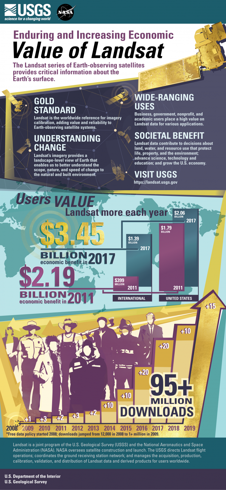
Infographic displaying the economic valuation of Landsat imagery.