
The USGS, in partnership with a network of national and global institutes, is developing a comprehensive Global Hyperspectral Imaging Spectral-library of Agricultural-Crops (GHISA). GHISA is developed from hyperspectral data collected via a variety of sensor platforms—satellite, drone, aircraft, and ground-based—for the leading world crops, which include wheat, rice, corn, soybeans, barley, sugarcane, pulses, and potatoes. The goal of GHISA is to provide well-defined spectral libraries of the agricultural crops considering their growth stages, management practices, agro-ecological zones, and other factors to characterize their biophysical, biochemical, and plant health condition. GHISA will help researchers compare, contrast, and study hyperspectral signatures of plants in various ways, thus advancing understanding of agricultural crops and vegetation through more accurate and precise classifications, models, maps, and monitoring capabilities. Specifically, GHISA spectral libraries will help advance (Figure 1): species identification, vegetation or crop types classification, biophysical property quantification, biochemical property quantification, disease and stress identification, nutrient mapping, moisture assessments, light use efficiency modeling, and net primary productivity modeling and mapping.
GHISA data will be used in studies such as: (1) data mining; (2) overcoming Hughes phenomenon (i.e., ensuring that each vegetation or crop class has enough training samples to train the classifier and an equally large number of training samples to establish the class accuracy); (3) establishing optimal hyperspectral narrowbands; (4) computing hyperspectral vegetation indices (HVIs); (5) discriminating species and cultivars; and (6) ensuring increased classification accuracies of crop, species, and vegetation types relative to multispectral broad bands. The strength of the HVIs lies in the fact that specific indices can be derived for specific biophysical, biochemical, and plant structural quantities. Currently, GHISA developed using the Earth Observing-1 Hyperion satellite instrument and handheld spectroradiometers is available for specific areas. GHISA for the United States is downloadable at https://lpdaac.usgs.gov/news/release-global-hyperspectral-imaging-spectral-library-agricultural-crops-conterminous-united-states/. GHISA for Central Asia is downloadable at https://lpdaac.usgs.gov/news/release-global-hyperspectral-imaging-spect….
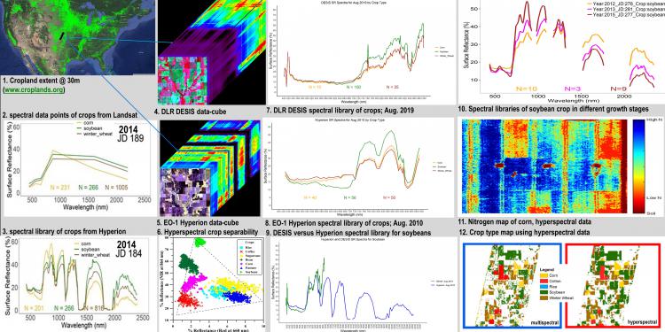
Hyperspectral data derived spectral signatures of agricultural crops to study biophysical, biochemical, and plant health variables.