
From May to September 2018, Kīlauea volcano experienced its largest eruption in more than 200 years. The eruption drained the summit lava lake and shallow magma reservoir, covering the volcano’s lower East Rift Zone in 35 square-kilometer of lava. Successive collapse events at the summit resulted in a collapsed crater more than 500-meter deep. In July 2019, a water lake began forming in the summit crater that continues to grow. The presence of water elevates the possibility of explosive hazards at Kīlauea. USGS Hawaiian Volcano Observatory (HVO) scientists require direct sampling of the lake to understand its source as well as whether gases from underlying magma are condensing, which provides critical monitoring data for forecasting future volcanic activity at the summit of Kīlauea. Sampling the summit lake via sUAS (small unmanned aircraft systems) eliminates the risk of manned aircraft entering an environment where lethal volcanic gas concentrations potentially exist and rockfalls are common from the steep caldera walls. Results indicate the lake is being fed by rainwater and that substantial amounts of sulfur dioxide (SO2), which would be emitted into the atmosphere in the absence of water, are instead dissolving in the lake (and/or the surrounding groundwater) and decreasing the rate of emission of SO2 into the atmosphere. Another possibility is that rain percolating into the ground (meteoric water recharge) is leaching sulfur-rich deposits that accumulated in the summit area before the lava lake drained. The pH of Kīlauea’s lake is ~4 (moderately acidic), and the temperature is roughly 160 degrees Fahrenheit. HVO plans to routinely sample the lake as it continues to grow and change to monitor chemistry and temperature levels that will help forecast future volcanic activity.
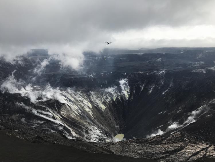
A water sampler and temperature probe attached to a multi-rotor UAS via a 30-foot cord is flown into Kīlauea’s Halema‘uma‘u summit crater to collect a water sample from the newly formed lake. Photo credit: Matthew Patrick, USGS.