
Migratory birds are highly dependent on major moist soil seed (MSS) as a food resource in the Central Valley of California, a major North American flyway. Using Landsat satellite data, researchers generated the first maps of the extent and productivity of major moist soil seed (MSS) plants including watergrass (Echinochloa crusgalli) and smartweed (Polygonum spp.) , and swamp timothy (Crypsis schoenoides) in all Central Valley–managed wetlands from 2007–2017. The effects of water year, land ownership, and region on plant area and productivity were tested with a multifactor nested analysis of variance. For the San Joaquin Valley, the team explored the association between water year and water supply and developed metrics to support management decisions. MSS plant area maps were based on a support vector machine classification of Landsat phenology metrics (2017 map overall accuracy: 89%). Swamp timothy (ST) productivity maps were created with a linear regression model of seed yield (n = 68, R2 = 0.53, normalized RMSE = 10.5%). The Central Valley–wide estimated area for ST in 2017 was 32,369 ± 2,524 hectares (95% C.I.), and 13,012 ± 1,384 hectares for watergrass and smartweed. Within the Central Valley Joint Venture planning basins, mean ST seed yield ranged from 577 kilogram per hectare in the Delta Basin to 365 kilogram per hectare in the San Joaquin Basin (https://www.centralvalleyjointventure.org/). Watergrass and smartweed area and ST seed yield decreased while ST area increased in critical drought years compared to normal water years (Scheffe’s test, p < 0.05). Greatest ST area increases occurred in the Sacramento Valley (~75%). Voluntary water deliveries increased in normal water years, and ST seed yield increased with water supply. A statistical method to track ST seed yield as Z-scores normalized by year can be used to evaluate wetland performance and aid resource allocation decisions. Updated maps will support habitat monitoring, conservation planning, and water management in future years, which are likely to face greater uncertainty in water availability with climate change.
https://doi.org/10.1002/eap.2153
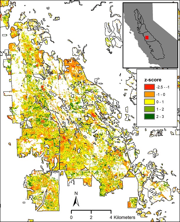
Greenness anomalies, or Z-scores, of swamp timothy seed yield for 2017 for the northern Grassland Ecological Area, San Joaquin Valley, California. Positive values represent above-average productivity and negative values represent below-average productivity relative to the time series of 2007–2017.