
Landsat Collection 1 Provisional Actual Evapotranspiration and Provisional Aquatic Reflectance datasets became available in fiscal year 2020 and are the most recent publicly released Landsat science products. These provisional products belong to a larger suite of USGS research-quality and application-ready Landsat science products aimed at reducing the burden of data processing for the user community. Provisional Actual Evapotranspiration (Eta) is the quantity of water that is removed from a surface due to the processes of evaporation and transpiration. Derived from the Landsat Collection 1 Level-2 Provisional Surface Temperature product, the ETa science product is generated by calculating the latent heat flux using the Operational Simplified Surface Energy Balance (SSEBop) model, and is useful for understanding the spatiotemporal dynamics of water use over land surfaces and for monitoring hydrologic, agricultural, and environmental systems. It is available for Landsat 4–5 Thematic Mapper, Landsat 7 Enhanced Thematic Mapper Plus, and Landsat 8 Operational Land Imager/Thermal Infrared Sensor scenes acquired over the conterminous United States from 1982–present. The other science product, Aquatic Reflectance, measures the spectral distribution of visible solar-reflected radiation upwelling from the upper water column and is useful for monitoring water quality, mapping chlorophyll concentrations, and measuring the inherent optical properties of water. The Provisional Aquatic Reflectance science product is derived from Landsat Collection 1 Level-1 reflective bands and is based on the Sea-viewing Wide Field-of-View Sensor (SeaWiFS) Data Analysis System (SeaDAS) that was developed by the National Aeronautical and Space Administration (NASA). It is currently available for Landsat 8 Operational Land Imager acquisitions only (2013–present). Landsat Collection 1 Provisional ETa and Aquatic Reflectance products are available through the USGS Earth Resources Observation and Science (EROS) Center Science Processing Architecture (ESPA) on-demand interface. Additional customization services such as reprojection, spatial subsetting, and pixel resizing are also available via ESPA. For additional information about ESPA and Landsat science products, visit the Landsat Missions website.
https://www.usgs.gov/land-resources/nli/landsat/landsat-science-products
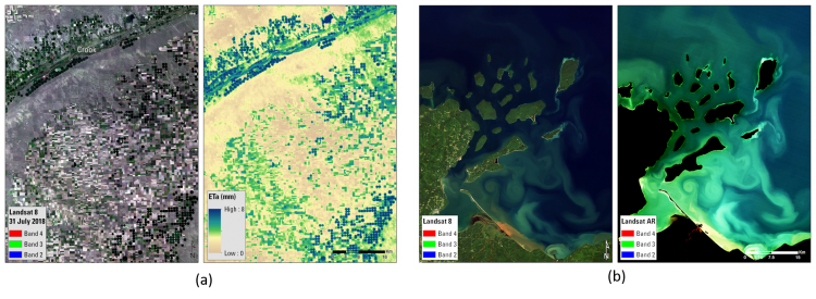
Examples of (a) Provisional Actual Evapotranspiration (ETa) and (b) Provisional Aquatic Reflectance (AR) science products derived from Landsat 8 data. Images (a) are in an agricultural area (N is to the top, image is ~60-km E-W). Images (b) are in a coastal area (N is to the top, image is ~50-km E-W)