
The USGS Earth Resources Observation and Science (EROS) Center has supported Burned Area Emergency Response (BAER) teams since 2001 by providing satellite image-derived burn severity products. BAER teams deploy to wildfire locations during and after fire events to quickly characterize the impact of wildfires to the affected and surrounding landscapes and provide stabilization and rehabilitation plans to safeguard values at risk. The starting point for these efforts is a Burned Area Reflectance Classification (BARC) map produced from Landsat and/or Sentinel-2 imagery. BARC maps are created by analysts at USGS EROS to support DOI BAER teams; similar products are created by the U.S. Forest Service (USFS) to support BAER teams on USFS lands. BARC maps are also utilized by the USGS Landslide Hazards Program to model post-fire debris flow risks to surrounding landscapes.
BARC map requests are received from BAER team coordinators and are filled as quickly as possible based on available imagery. When suitable imagery is already available, BARC maps can be completed and provided to the BAER teams within 1–2 hours of the request being made. If suitable imagery is not yet available, the analysts communicate with the BAER team about when the next image acquisitions are scheduled so they can plan accordingly. For large long-duration incidents, BARC maps may be generated several times for the same fire to capture the ongoing growth and change occurring during the incident. Over the past 20 years, USGS and USFS analysts have mapped over 2,000 fires and over 55 million acres to support BAER teams.
In 2020, USGS EROS started offering an additional suite of burn severity products to support BAER teams. USGS analysts were trained in the USFS Rapid Assessment of Vegetation Condition After Wildfire (RAVG) program methodologies and are now able to generate RAVG products for DOI BAER teams. RAVG products are specific to forested landscapes; they provide estimates of canopy cover loss, basal area loss, and composite burn index, a ground-based indicator of burn severity. These products help the Department of the Interior agencies that manage timber resources to better characterize changes caused by wildfire.
https://www.usgs.gov/centers/eros/science/burned-area-emergency-response-support
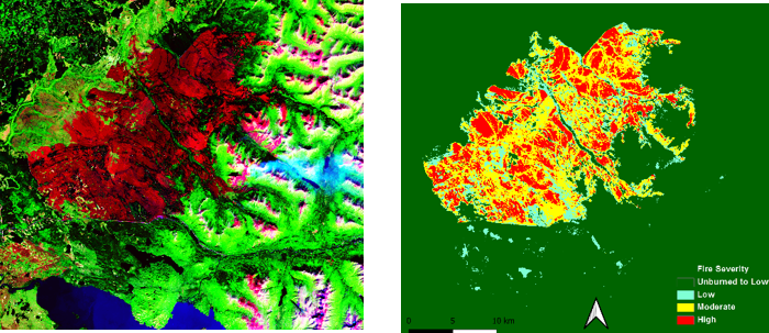
Sentinel-2A image of the Swan Lake Fire in Alaska, acquired 16 August 2019 (left) and the preliminary BARC map (right). The fire, at the time it was mapped, was over 163,000 acres.