
The USGS Fire Danger Forecast Program develops daily depictions of the potential for large wildfire occurrence based on vegetation and weather conditions for the conterminous U.S. Several products are made available each day, including the Fire Potential Index, Probability of Large Fire Occurrence, and the Expected Number of Large Fires per forecast area. These products have been created continuously for many years utilizing daily Advanced Very High-Resolution Radiometer (AVHRR) imagery and weather forecast data from the National Weather Service. Recent efforts have been made to modernize the algorithms used to generate these data and expand the program to create new products.
The first enhancement was to transition the daily products to utilize Moderate Resolution Imaging Spectroradiometer (MODIS) data, as the AVHRR sensors were reaching end of life and no longer reliably collecting daily imagery. An analysis was completed showing minimal differences between AVHRR- and MODIS-based fire danger forecast products. Next, new products were developed to incorporate the effects of wind, temperature, precipitation, and snow/ice cover into the fire danger forecast products. These provisional products are being created operationally and distributed for data users to compare against the traditional products. Once sufficient provisional data have been generated and characterized, they may eventually replace the traditional products. Last, the program’s web-based data distribution system was updated to a new viewer with enhanced capabilities and a fresh new look.
Statistical analysis of the MODIS-based historical products and the new provisional products is ongoing to validate the product forecast skill and accurately estimate the probability of wildfire occurrence based on historical fire occurrence. Additional work is anticipated to transition data processing once again to utilize the Visible Infrared Imaging Radiometer Suite (VIIRS) sensor as MODIS data may also be nearing end of life. A similar analysis of the difference in data products between MODIS- and VIIRS-derived images will be completed, and the data processing algorithms updated accordingly. Finally, the latest updates to the Fire Danger Forecast Program algorithms and products are being documented and will be published in the near future.
https://www.usgs.gov/land-resources/lcsp/fire-danger-forecast
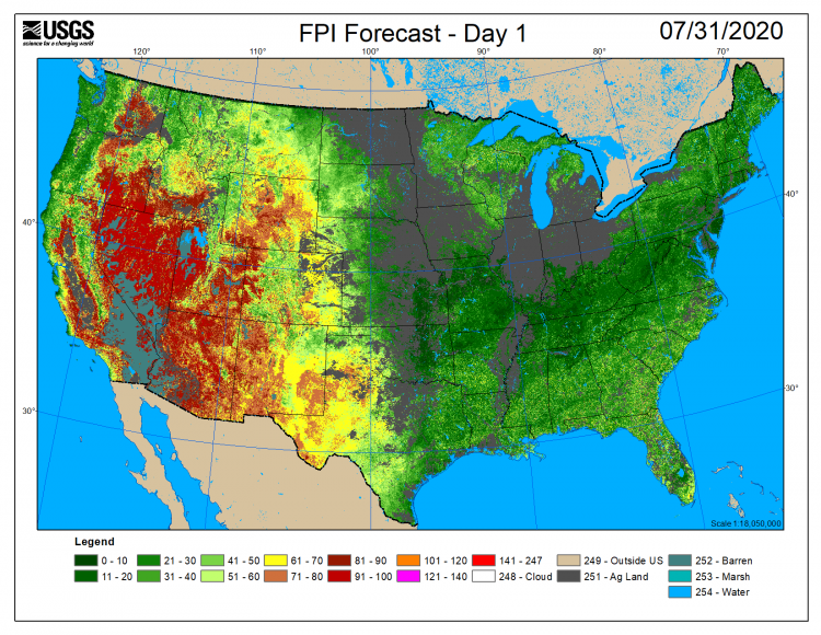
Fire potential index data for July 31, 2020. Warmer colors indicate higher potential for large wildfire activity.