
The estimation and mapping of evapotranspiration (ET) is an active area of applied USGS research in the fields of agriculture and water resources. Specifically, combining remote sensing data along with climate and other weather information in a cloud-based compute framework has illustrated the value of next-generation ET mapping for nationwide water use information.
Scientists at the USGS Earth Resources Observation and Science (EROS) Center are leveraging the thermal (surface temperature) components of the Landsat satellite imagery archive to create ET products using the Operational Simplified Surface Energy Balance (SSEBop) model. Recently, over 150,000 Landsat images were used to generate 10 years of annual ET (2010–2019) at unprecedented scale and speed. This accomplishment represents the first-ever set of Landsat ET maps for the conterminous United States at this spatial (30-meter) resolution and temporal (annual) interval. Data will be made freely available with an upcoming product and manuscript release.
An accuracy assessment of the SSEBop results included a point-based evaluation using monthly Eddy Covariance (EC) data from 29 AmeriFlux stations (up to R2 > 0.80) as well as a basin-scale comparison with annual Water Balance (WB) ET estimates (R2 > 0.90) using more than 2,000 sub-basins. Evaluations using EC and WB datasets indicated that the SSEBop model is strong in explaining spatially variable seasonal trends at local and regional levels where water management operates the most. Most importantly, in addition to new data understanding and supporting model enhancements, this work facilitates broader collective opportunities for those in search of increasing timeliness and availability of accurate ET information.
The EROS Center develops and shares these ET products with USGS Water Science Centers around the Nation for use in water availability and use studies and localized applications. The data are also instrumental for meeting the National Water Census reporting requirements in addition to numerous collaborative efforts among various Federal and State agencies, universities, and others.
https://earlywarning.usgs.gov/ssebop
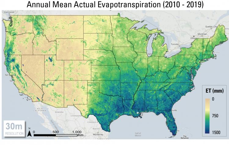
Annual Total Evapotranspiration using 10-year average (2010–2019) data from the Landsat-based SSEBop ETa.