
In 2018, members of the USGS Western Ecological Research Center (WERC) Dixon Field Station attached Global Positioning System-Global System for Mobile Communication (GPS-GSM) accelerometer transmitters to 257 geese and 300 ducks to monitor migration patterns and behavior, with the end goal of providing timely and actionable data for their project cooperators. The WERC Dixon Field Station is located in the Central Valley of California and is a main resource for waterfowl research within the Pacific Flyway. A component of the field station's research is focused on the breeding patterns and wintering ecology of the waterfowl in the Suisun Marsh and Central Valley. The group's research seeks to understand how the behavior and foraging patterns of an increasing migratory geese population in the Central Valley affects food availability for other resident waterfowl species in the Suisun Marsh.
To effectively meet project goals, the team needed the ability to ingest and store a massive amount of transmitted location and movement data, as well as the compute capacity to process this data into meaningful behavior and life history observations in a useful time frame. Based on these needs, the team utilized the USGS Cloud Hosting Solutions (CHS) program’s Cloud Sensor Processing Framework (CSPF) for the acquisition, storage, processing, and analysis of their data. The CSPF ingested data from the GPS-GSM transmitters as delivered (up to every 15 minutes) when there was an available cellular connection. The CSPF processed incoming location and movement data to send alerts to project cooperators informing them of mortality events, birds returning from areas out of cellular range, and when birds entered a specific area of interest. After processing and sending alerts, the CSPF stored data in a cloud database for long-term retention and preparation for data visualization. The USGS CHS Tableau Servers were used to deliver actionable science to project cooperators via the creation of an interactive dashboard that visualized goose migration paths and flight metrics.
https://atthecore.usgs.gov/science-support/cloud-hosting-solutions-chs
![]()
Geographical Positioning Systems-Global Systems for Mobile Communication (GPS-GSM) accelerometer transmitter attached to waterfowl. Photo credit: Andrea Mott, USGS
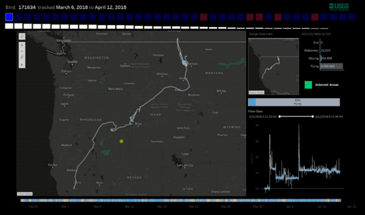
Tableau dashboard visualizing goose migration paths and flight metrics.