
The emergent proliferation of Synthetic Aperture Radar (SAR) imaging systems, related advancements in image processing and exploitation capabilities, and the increasing availability of analysis-ready SAR data products have enhanced the BLM’s ability to use remote sensing-derived information to support resource management. SAR is valuable to land managers for multiple reasons: the data can be collected regardless of time of day or weather condition, unlike optical imagery, which requires clear daytime conditions; SAR systems that can transmit and receive multiple polarization states offer the ability to differentiate and classify land cover types; and Interferometric Synthetic Aperture Radar (InSAR) techniques can be used to resolve fine-scale surface changes over time.
Two important examples where SAR imagery is being used to help address key BLM management concerns are wetlands monitoring and wildfire management. Sentinel-1 is being used for each of these applications because it collects moderate-resolution SAR satellite data and offers repeat, consistent worldwide coverage.
Wetland mapping and monitoring of surface water cover trends leverage Sentinel-1’s spatial resolution, polarization, and revisit capabilities to provide a further understanding of wetland inundation dynamics. The example in Figures A and B identifies a decrease in surface water within the Wood River Wetland in Oregon between Sentinel-1 image dates in July 2021. These decreases are identified in water cover with and without inundated vegetation, shown as yellow and blue pixels, respectively.
The National Operations Center (NOC) also uses Sentinel-1 to develop products that support the BLM’s Emergency Stabilization and Rehabilitation (ESR) program, as well as for other post-fire monitoring activities. Change detection analysis of pre- and post-fire SAR imagery is used to delineate burn extents. Coherence products developed using InSAR techniques, which capture the complex correlations between multi-temporal InSAR images, are used to provide fire severity estimates for affected rangeland and forest cover. As the Oil Springs Fire example shows in Figures C and D, InSAR coherence tends to be negatively correlated with severity, so that extremely low coherence values typically represent moderate- to high-severity burned areas. Sentintel-1 SAR products are especially useful for post-fire management when electro-optical imagery is unavailable or unreliable due to weather and fire effects.
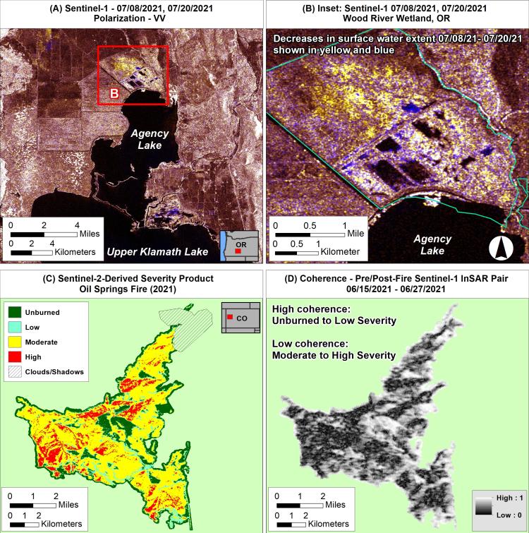
Examples of SAR imagery supporting BLM wetlands monitoring and wildfire management, respectively. (A) Sentinel-1 image composite of data collected over southern Oregon on July 8 and July 20, 2021. (B) Inset showing water decreases at BLM-administered Wood River Wetland between these dates at full image resolution. These decreases are identified in water cover with and without inundated vegetation, shown as yellow and blue pixels, respectively. (C) Severity product for Oil Springs Fire in Colorado, derived from Sentinel-2 electro-optical imagery. (D) Coherence product derived from pre- and post-event Sentinel-1 imagery using InSAR techniques. SAR products can be useful for post-fire management when electro-optical imagery is unavailable.