
Abandoned gas and oil wells are commonly a source of greenhouse gas (GHG) emissions and can leak hydrocarbon-related fluids such as oil or brine, particularly when unplugged wells go undetected over long periods. Older wells are challenging to discover when vegetation has overgrown abandoned sites. As in other parts of the country, FWS National Wildlife Refuges (NWR) in Oklahoma and Texas contain a large number of abandoned wells from historical oil and gas development. Inventory of these wells and their mitigation (e.g., plugging and abandoning wells, remediation of site, removal of old equipment) may help reduce potential GHG emissions and safety hazards. Remotely sensed data and deep learning automated object detection may be useful for detecting abandoned well infrastructure.
Construction of oil and gas well pads alters the terrain by creating a soil berm and neighboring leveled surfaces. Once overgrown by vegetation, these features persist but are difficult to see visually. As a proof-of-concept approach, researchers attempted to capture these unique terrain features using laser airborne light detection and ranging (lidar) data collected with over 8 returns per square-meter (QL1 data) on the Deep Fork NWR. Multiple returns from lidar can generate precise bare-earth elevation measures and potentially reveal terrain conditions that are associated with these abandoned well infrastructure.
Researchers developed a map of suspected well site features from QL1 lidar data using a Convolutional Neural Network (CNN) classifier (a type of artificial intelligence) to locate and validate in the field. Of the 39 sites mapped as wells, 82% were positive and contained signs of well infrastructure, such as evidence of pad construction, wellhead, or pipes. Of these sites, 18 were not included in the original training dataset producing a true positive rate of 66.7%. Overall, well detection using CNN proved effective for detecting and mapping potential well locations that were previously unknown and could be discovered with targeted field surveys.
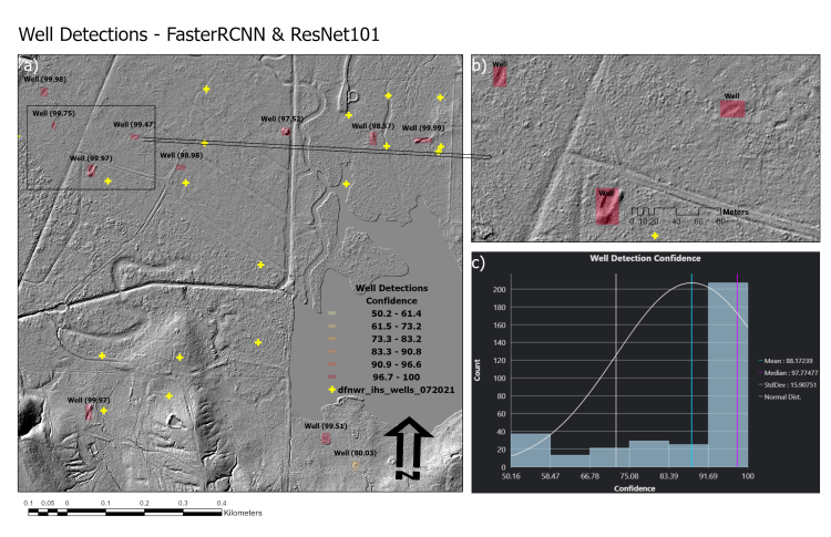
(a) Well site detections on Deep Fork National Wildlife Refuge in Oklahoma predicted by the CNN model, shown in shades of magenta according to model confidence. The yellow crosses depict potential well site locations from an alternate inventory. (b) Close-up of the inset area showing lidar hillshade map with well terrain features. (c) Graph showing the distribution of confidence levels for all well site detections. Model confidence is based on the similarity of features associated with well site detections to those of the known well site locations used to train the model.