
Mixed composition and bottomland hardwood forests are essential habitat for imperiled songbird populations on Texas and Oklahoma National Wildlife Refuges (NWR). Point-count data were collected for focal songbird species on five refuges together with remotely sensed data to estimate densities and model habitat relationships. Forest vegetation was classified into general composition categories that may influence avian species distributions including deciduous forest, coniferous forest, and wetland vegetation. To develop mapped categories, researchers calculated monthly measures of vegetation greenness and greenness dynamics from PlanetScope satellite data, including modified triangular vegetation index 2 (MTVI2, calculated using the green, red and near-infrared reflectance data) and time series MTVI2, extracting minimum, maximum, and amplitude values. Airborne light detection and ranging (lidar) data were used to generate a canopy height model (CHM) as well as measures of canopy leaf area index (LAI) and density via 3D voxel analysis. All data were developed and combined at 4-meter pixel resolution. Classification training and test data for mapped categories were developed from satellite and high-resolution (less than 1- meter pixels) aerial imagery.
The preliminary classification model for Neches River NWR using supervised random forest classification trees showed good results with model accuracy ranging from 82% to 84% correctly classified pixels from training samples left ‘out-of-bag’ with replacement; sparse test data held out of model training yielded 77% overall accuracy. The most important variable for separating coniferous and deciduous forest was MTVI2 coefficients of variation (CV) from a one-year growing season cycle and lidar CHM. Wetlands showed complex relationships to individual MTVI2 dates, and lidar metrics were less important for this vegetation category.
Mapped categories provide accurate but general vegetation categories for evaluating habitat conditions and spatial patterns through time. Detailed classification models to distinguish tree species groups or wetland types may be improved by field data or measures associated with inundation patterns to help distinguish potential composition differences. Eight-channel PlanetScope imagery aboard the recently launched SuperDove satellites may further aid mapping detailed vegetation categories in these environments.
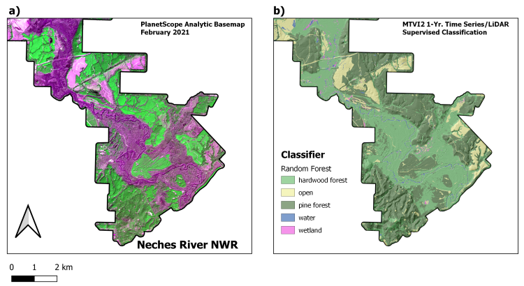
Resulting vegetation categories mapped for the Neches River NWR using Random Forest Classification with vegetation derivatives from PlanetScope satellite data and Airborne light detection and ranging (lidar) data.